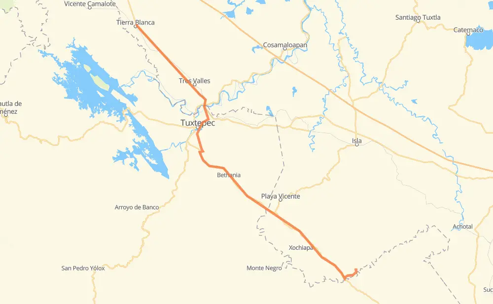
Distance between Tierra Blanca and Nuevo San Martín
The distance from Tierra Blanca to Nuevo San Martín is 99 miles by road. Road takes approximately 2 hours and 8 minutes and goes through Tres Valles, San Juan Bautista Tuxtepec, Novara, Colonia Adolfo Ruiz Cortines (Colonia Obrera), Gabino Barreda, Papaloapan and Pueblo Nuevo Papaloápam.
| Shortest distance by air | 81 mi ✈️ |
| Car route length | 99.4 mi 🚗 |
| Driving time | 2 h 8 min |
| Fuel amount | 3.4 gal |
| Fuel cost | 13.3 USD |
| Toll roads cost | 24 MXN |
| Point | Distance | Time | Fuel | |
| Tierra Blanca | 0 mi | 00 min | 0.0 gal | |
|
13 mi, 16 min
|
||||
| Novara | 13 mi | 16 min | 0.0 gal | |
|
MEX 145 13 mi, 15 min
|
||||
| Gabino Barreda | 26 mi | 31 min | 0.9 gal | |
|
MEX 145 1 mi, 01 min
|
||||
| Papaloapan | 27 mi | 33 min | 0.9 gal | |
|
MEX 145 1 mi, 01 min
|
||||
| Pueblo Nuevo Papaloápam | 28 mi | 34 min | 0.9 gal | |
|
MEX 145 4 mi, 05 min
|
||||
| Agua Fría Papaloapan | 32 mi | 39 min | 1.0 gal | |
|
4 mi, 05 min
|
||||
| Colonia Ortega | 37 mi | 45 min | 1.2 gal | |
|
MEX 147 9 mi, 13 min
|
||||
| Rodeo Arroyo Pepesca | 46 mi | 59 min | 1.5 gal | |
|
MEX 147 6 mi, 06 min
|
||||
| Bethania | 51 mi | 1 h 06 min | 1.6 gal | |
|
MEX 147 48 mi, 1 h 02 min
|
||||
| Nuevo San Martín | 99 mi | 2 h 08 min | 3.2 gal | |
Frequently Asked Questions
How many toll booths are there from Tierra Blanca to Nuevo San Martín?
There are 1 tollbooth between Tierra Blanca and Nuevo San Martín: Papaloapan.
How much does the toll booths cost from Tierra Blanca to Nuevo San Martín?
Toll roads cost: Papaloapan (24 MXN) = 24 MXN
How much does it cost to drive from Tierra Blanca to Nuevo San Martín?
Fuel cost: 13.3 USD
This fuel cost is calculated as: (Route length 99.4 mi) / (Fuel consumption 29.4 mpg) * (Fuel price 3.93 USD / gal)
You can adjust fuel consumption and fuel price here.
Toll roads cost: 24 MXN
How long is a car ride from Tierra Blanca to Nuevo San Martín?
Driving time: 2 h 8 min
This time is calculated for driving at the maximum permitted speed, taking into account traffic rules restrictions.
- 2 mi with a maximum speed 56 mph = 1 min
- 86 mi with a maximum speed 50 mph = 1 h 43 min
- 1 mi with a maximum speed 37 mph = 1 min
- 11 mi with a maximum speed 31 mph = 20 min
The calculated driving time does not take into account intermediate stops and traffic jams.
How far is Tierra Blanca to Nuevo San Martín by land?
The distance between Tierra Blanca and Nuevo San Martín is 99.4 mi by road.
Precise satellite coordinates of highways were used for this calculation. The start and finish points are the centers of Tierra Blanca and Nuevo San Martín respectively.
How far is Tierra Blanca to Nuevo San Martín by plane?
The shortest distance (air line, as the crow flies) between Tierra Blanca and Nuevo San Martín is 81.4 mi.
This distance is calculated using the Haversine formula as a great-circle distance between two points on the surface of a sphere. The start and finish points are the centers of Tierra Blanca and Nuevo San Martín respectively. Actual distance between airports may be different.
How many hours is Tierra Blanca from Nuevo San Martín by plane?
Boeing 737 airliner needs 9 min to cover the distance of 81 mi at a cruising speed of 497 mph.
Small plane "Cessna 172" needs 35 min to flight this distance at average speed of 136 mph.
This time is approximate and do not take into account takeoff and landing times, airport location and other real world factors.
How long is a helicopter ride from Tierra Blanca to Nuevo San Martín?
Fast helicopter "Eurocopter AS350" or "Hughes OH-6 Cayuse" need 32 min to cover the distance of 81 mi at a cruising speed of 149 mph.
Popular "Robinson R44" needs 37 min to flight this distance at average speed of 130 mph.
This time is approximate and do not take into account takeoff and landing times, aerodrome location and other real world factors.
What city is halfway between Tierra Blanca and Nuevo San Martín?
The halfway point between Tierra Blanca and Nuevo San Martín is Bethania. It is located about 2 mi from the exact midpoint by road.
The distance from Bethania to Tierra Blanca is 51 mi and driving will take about 1 h 5 min. The road between Bethania and Nuevo San Martín has length 48 mi and will take approximately 1 h 2 min.
The other cities located close to halfway point:
Where is Tierra Blanca in relation to Nuevo San Martín?
Tierra Blanca is located 81 mi north-west of Nuevo San Martín.
Tierra Blanca has geographic coordinates: latitude 18.45053, longitude -96.35498.
Nuevo San Martín has geographic coordinates: latitude 17.58055, longitude -95.52639.
Which highway goes from Tierra Blanca to Nuevo San Martín?
The route from Tierra Blanca to Nuevo San Martín follows MEX 147, MEX 145.