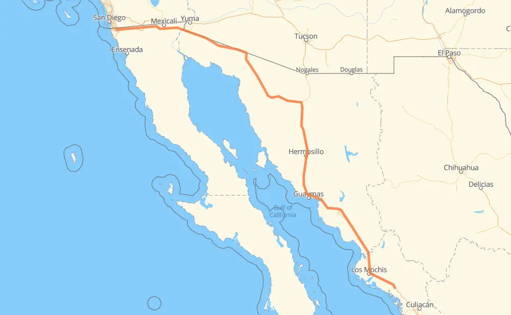
The distance from Tijuana to Angostura is 899 miles by road including 585 miles on motorways. Road takes approximately 16 hours and 24 minutes and goes through San Luis Rio Colorado, Heroica Caborca, Hermosillo, Navojoa, Los Mochis and Gabriel Leyva Solano.
You can adjust fuel consumption and fuel price here.
Toll roads cost:
631 + ? MXN
How long is a car ride from Tijuana to Angostura?
Driving time:
16 h 24 min
This time is calculated for driving at the maximum permitted speed, taking into account traffic rules restrictions.
161 mi with a maximum speed 68 mph = 2 h 21 min
158 mi with a maximum speed 62 mph = 2 h 32 min
17 mi with a maximum speed 56 mph = 18 min
220 mi with a maximum speed 56 mph = 3 h 56 min
307 mi with a maximum speed 50 mph = 6 h 10 min
31 mi with a maximum speed 37 mph = 50 min
3 mi with a maximum speed 31 mph = 5 min
1 mi with a maximum speed 25 mph = 1 min
1 mi with a maximum speed 12 mph = 1 min
1 mi with a maximum speed 6 mph = 6 min
The calculated driving time does not take into account intermediate stops and traffic jams.
How far is Tijuana to Angostura by land?
The distance between Tijuana and Angostura is 899.1 mi by road including 584.7 mi on motorways.
Precise satellite coordinates of highways were used for this calculation. The start and finish points are the centers of Tijuana and Angostura respectively.
How far is Tijuana to Angostura by plane?
The shortest distance (air line, as the crow flies) between Tijuana and Angostura is 725.1 mi.
This distance is calculated using the Haversine formula as a great-circle distance between two points on the surface of a sphere. The start and finish points are the centers of Tijuana and Angostura respectively. Actual distance between airports may be different.
How many hours is Tijuana from Angostura by plane?
Boeing 737 airliner needs 1 h 27 min to cover the distance of 725 mi at a cruising speed of 497 mph.
Small plane "Cessna 172" needs 5 h 18 min to flight this distance at average speed of 136 mph.
This time is approximate and do not take into account takeoff and landing times, airport location and other real world factors.
How long is a helicopter ride from Tijuana to Angostura?
Fast helicopter "Eurocopter AS350" or "Hughes OH-6 Cayuse" need 4 h 51 min to cover the distance of 725 mi at a cruising speed of 149 mph.
Popular "Robinson R44" needs 5 h 33 min to flight this distance at average speed of 130 mph.
This time is approximate and do not take into account takeoff and landing times, aerodrome location and other real world factors.
What city is halfway between Tijuana and Angostura?
The halfway point between Tijuana and Angostura is Casa Blanca. It is located about 1 mi from the exact midpoint by road.
The distance from Casa Blanca to Tijuana is 448 mi and driving will take about 8 h 20 min. The road between Casa Blanca and Angostura has length 451 mi and will take approximately 8 h 4 min.
The other cities located close to halfway point:
La Noria is in 453 mi from Tijuana and 446 mi from Angostura
La Barajita is in 445 mi from Tijuana and 454 mi from Angostura
San Fernando is in 457 mi from Tijuana and 442 mi from Angostura
Where is Tijuana in relation to Angostura?
Tijuana is located 725 mi north-west of Angostura.
Tijuana has geographic coordinates: latitude 32.50086, longitude -116.96417.
Angostura has geographic coordinates: latitude 25.36689, longitude -108.16295.
Which highway goes from Tijuana to Angostura?
The route from Tijuana to Angostura follows MEX 15D, MEX 2, MEX 2D.