Distance between Tlacotalpan and Agiabampo Dos
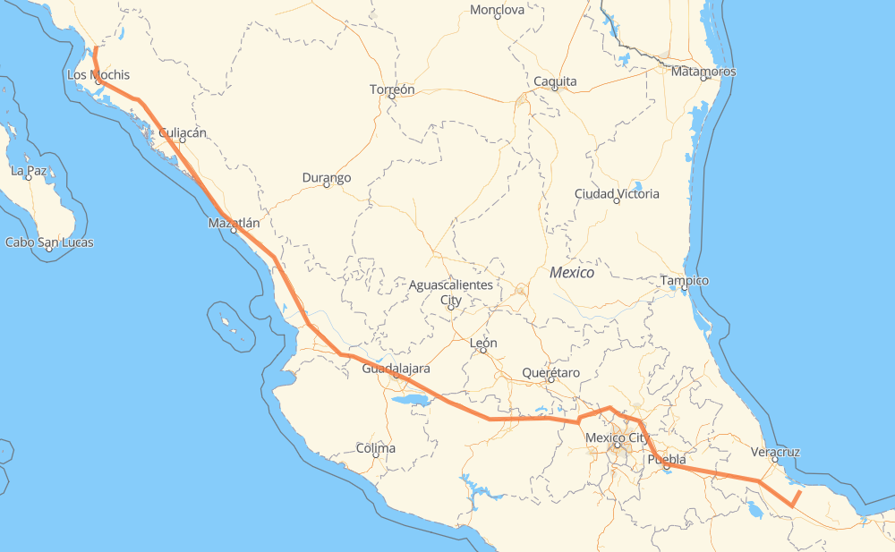
The distance from Tlacotalpan to Agiabampo Dos is 1,220 miles by road including 1,184 miles on motorways. Road takes approximately 21 hours and 16 minutes and goes through Orizaba, Tonalá, Tepic, Dimas (Estación Dimas), Gabriel Leyva Solano and Los Mochis.
| Shortest distance by air | 1,008 mi ✈️ |
| Car route length | 1,219.8 mi 🚗 |
| Driving time | 21 h 16 min |
| Fuel amount | 41.5 gal |
| Fuel cost | 161.8 USD |
| Toll roads cost | 2,868 + ? MXN |
| Point | Distance | Time | Fuel | |
| Tlacotalpan | 0 mi | 00 min | 0.0 gal | |
|
MEX 175 16 mi, 19 min
|
||||
| Carlos A. Carrillo | 16 mi | 19 min | 0.0 gal | |
|
MEX 175 MEX 145D 111 mi, 1 h 49 min
|
||||
| Ixtaczoquitlán | 126 mi | 2 h 09 min | 4.3 gal | |
|
MEX 150D 3 mi, 03 min
|
||||
| Orizaba | 129 mi | 2 h 12 min | 4.3 gal | |
|
MEX 150D MEX 15D 492 mi, 8 h 45 min
|
||||
| Tonalá | 621 mi | 10 h 57 min | 21.0 gal | |
|
MEX 15D 138 mi, 2 h 17 min
|
||||
| Tepic | 759 mi | 13 h 15 min | 25.6 gal | |
|
MEX 15D 207 mi, 3 h 22 min
|
||||
| Dimas (Estación Dimas) | 966 mi | 16 h 37 min | 32.6 gal | |
|
MEX 15D 180 mi, 3 h 10 min
|
||||
| Gabriel Leyva Solano | 1,146 mi | 19 h 48 min | 38.7 gal | |
|
MEX 15D 27 mi, 31 min
|
||||
| Los Mochis | 1,173 mi | 20 h 19 min | 39.8 gal | |
|
MEX 15D 47 mi, 56 min
|
||||
| Agiabampo Dos | 1,220 mi | 21 h 15 min | 41.5 gal | |
Frequently Asked Questions
How many toll booths are there from Tlacotalpan to Agiabampo Dos?
There are 31 toll booths between Tlacotalpan and Agiabampo Dos: Fortín, Cuitláhuac, Cosamaloapan, San Miguel, Sinaloa, Las Brisas, San Pedro km 197+100, Costa Rica, Marmol, El Rosario, Acaponeta, Ruiz, Trapichillo, Santa Maria del Oro, Plan de Barrancas, La Joya, Ocotlán, Zinapecuaro, Contepec, Panindicuaro, Ecuandureo, Atlacomulco — Maravatio, Atlacomulco 2, San Martin Texmelucan, San Martín, Amozoc 2, Amozoc, Esperanza 27, Arenal and El Pisal.
How much does the toll booths cost from Tlacotalpan to Agiabampo Dos?
Toll roads cost: Cosamaloapan (189 MXN) + Cosamaloapan (189 MXN) + Cuitláhuac (114 MXN) + Fortín (33 MXN) + Esperanza 27 (140 MXN) + Amozoc (72 MXN) + Amozoc 2 (81 MXN) + San Martín (42 MXN) + San Martin Texmelucan (?) + Atlacomulco 2 (?) + Atlacomulco — Maravatio (50 MXN) + Contepec (?) + Zinapecuaro (161 MXN) + Panindicuaro (?) + Ecuandureo (111 MXN) + Ocotlán (226 MXN) + La Joya (?) + Arenal (131 MXN) + Plan de Barrancas (195 MXN) + Santa Maria del Oro (115 MXN) + Trapichillo (80 MXN) + Ruiz (?) + Acaponeta (240 MXN) + El Rosario (140 MXN) + Marmol (131 MXN) + Costa Rica (152 MXN) + San Pedro km 197+100 (34 MXN) + El Pisal (73 MXN) + Las Brisas (76 MXN) + Sinaloa (24 MXN) + San Miguel (69 MXN) = 2,868 + ? MXN
How much does it cost to drive from Tlacotalpan to Agiabampo Dos?
Fuel cost: 161.8 USD
This fuel cost is calculated as: (Route length 1,219.8 mi) / (Fuel consumption 29.4 mpg) * (Fuel price 3.9 USD / gal)
You can adjust fuel consumption and fuel price here.
Toll roads cost: 2,868 + ? MXN
How long is a car ride from Tlacotalpan to Agiabampo Dos?
Driving time: 21 h 16 min
This time is calculated for driving at the maximum permitted speed, taking into account traffic rules restrictions.
- 203 mi with a maximum speed 68 mph = 2 h 58 min
- 556 mi with a maximum speed 62 mph = 8 h 56 min
- 2 mi with a maximum speed 56 mph = 2 min
- 9 mi with a maximum speed 56 mph = 10 min
- 432 mi with a maximum speed 50 mph = 8 h 41 min
- 10 mi with a maximum speed 43 mph = 13 min
- 6 mi with a maximum speed 37 mph = 8 min
- 1 mi with a maximum speed 25 mph = 2 min
The calculated driving time does not take into account intermediate stops and traffic jams.
How far is Tlacotalpan to Agiabampo Dos by land?
The distance between Tlacotalpan and Agiabampo Dos is 1,219.8 mi by road including 1,184.3 mi on motorways.
Precise satellite coordinates of highways were used for this calculation. The start and finish points are the centers of Tlacotalpan and Agiabampo Dos respectively.
How far is Tlacotalpan to Agiabampo Dos by plane?
The shortest distance (air line, as the crow flies) between Tlacotalpan and Agiabampo Dos is 1,007.9 mi.
This distance is calculated using the Haversine formula as a great-circle distance between two points on the surface of a sphere. The start and finish points are the centers of Tlacotalpan and Agiabampo Dos respectively. Actual distance between airports may be different.
How many hours is Tlacotalpan from Agiabampo Dos by plane?
Boeing 737 airliner needs 2 h 1 min to cover the distance of 1,008 mi at a cruising speed of 497 mph.
Small plane "Cessna 172" needs 7 h 22 min to flight this distance at average speed of 136 mph.
This time is approximate and do not take into account takeoff and landing times, airport location and other real world factors.
How long is a helicopter ride from Tlacotalpan to Agiabampo Dos?
Fast helicopter "Eurocopter AS350" or "Hughes OH-6 Cayuse" need 6 h 45 min to cover the distance of 1,008 mi at a cruising speed of 149 mph.
Popular "Robinson R44" needs 7 h 43 min to flight this distance at average speed of 130 mph.
This time is approximate and do not take into account takeoff and landing times, aerodrome location and other real world factors.
What city is halfway between Tlacotalpan and Agiabampo Dos?
The halfway point between Tlacotalpan and Agiabampo Dos is Tonalá. It is located about 11 mi from the exact midpoint by road.
The distance from Tonalá to Tlacotalpan is 621 mi and driving will take about 10 h 57 min. The road between Tonalá and Agiabampo Dos has length 599 mi and will take approximately 10 h 19 min.
The other cities located close to halfway point:
Where is Tlacotalpan in relation to Agiabampo Dos?
Tlacotalpan is located 1,008 mi south-east of Agiabampo Dos.
Tlacotalpan has geographic coordinates: latitude 18.61211, longitude -95.66116.
Agiabampo Dos has geographic coordinates: latitude 26.4052, longitude -109.02798.
Which highway goes from Tlacotalpan to Agiabampo Dos?
The route from Tlacotalpan to Agiabampo Dos follows MEX 15D, MEX 150D, MEX M40D.
Other minor sections pass along the road:
- MEX 145D: 52 mi
- MEX 175: 30 mi
- MEX 70: 21 mi
- MEX 90: 21 mi
- MEX 80D: 11 mi
- MEX 80: 7 mi
- MEX 23: 5 mi
- MEX 040D: 4 mi
- MEX 140D: 1 mi