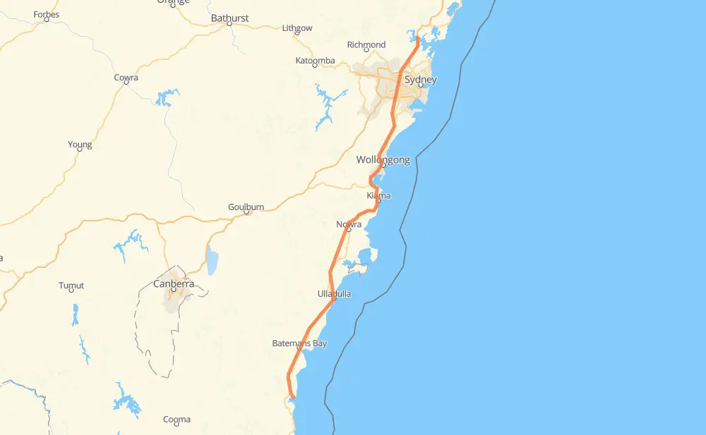
The distance from Tuross Head to Bar Point is 226 miles by road including 52 miles on motorways. Road takes approximately 4 hours and 17 minutes and goes through Moruya, Batemans Bay, Cockwhy, Lake Tabourie, Woodburn, Ulladulla and Milton.
You can adjust fuel consumption and fuel price here.
How long is a car ride from Tuross Head to Bar Point?
Driving time:
4 h 17 min
This time is calculated for driving at the maximum permitted speed, taking into account traffic rules restrictions.
28 mi with a maximum speed 68 mph = 24 min
16 mi with a maximum speed 62 mph = 15 min
101 mi with a maximum speed 56 mph = 1 h 48 min
6 mi with a maximum speed 56 mph = 6 min
32 mi with a maximum speed 50 mph = 39 min
26 mi with a maximum speed 43 mph = 35 min
12 mi with a maximum speed 37 mph = 20 min
4 mi with a maximum speed 31 mph = 6 min
The calculated driving time does not take into account intermediate stops and traffic jams.
How far is Tuross Head to Bar Point by land?
The distance between Tuross Head and Bar Point is 226.2 mi by road including 51.6 mi on motorways.
Precise satellite coordinates of highways were used for this calculation. The start and finish points are the centers of Tuross Head and Bar Point respectively.
How far is Tuross Head to Bar Point by plane?
The shortest distance (air line, as the crow flies) between Tuross Head and Bar Point is 185.2 mi.
This distance is calculated using the Haversine formula as a great-circle distance between two points on the surface of a sphere. The start and finish points are the centers of Tuross Head and Bar Point respectively. Actual distance between airports may be different.
How many hours is Tuross Head from Bar Point by plane?
Boeing 737 airliner needs 22 min to cover the distance of 185 mi at a cruising speed of 497 mph.
Small plane "Cessna 172" needs 1 h 21 min to flight this distance at average speed of 136 mph.
This time is approximate and do not take into account takeoff and landing times, airport location and other real world factors.
How long is a helicopter ride from Tuross Head to Bar Point?
Fast helicopter "Eurocopter AS350" or "Hughes OH-6 Cayuse" need 1 h 14 min to cover the distance of 185 mi at a cruising speed of 149 mph.
Popular "Robinson R44" needs 1 h 25 min to flight this distance at average speed of 130 mph.
This time is approximate and do not take into account takeoff and landing times, aerodrome location and other real world factors.
What city is halfway between Tuross Head and Bar Point?
The halfway point between Tuross Head and Bar Point is Berry.
The distance from Berry to Tuross Head is 113 mi and driving will take about 2 h 11 min. The road between Berry and Bar Point has length 113 mi and will take approximately 2 h 5 min.
The other cities located close to halfway point:
Broughton Village is in 117 mi from Tuross Head and 109 mi from Bar Point
Jaspers Brush is in 109 mi from Tuross Head and 117 mi from Bar Point
Meroo Meadow is in 106 mi from Tuross Head and 120 mi from Bar Point
Where is Tuross Head in relation to Bar Point?
Tuross Head is located 185 mi south-west of Bar Point.
Tuross Head has geographic coordinates: latitude -36.05945, longitude 150.13811.
Bar Point has geographic coordinates: latitude -33.51459, longitude 151.16378.
Which highway goes from Tuross Head to Bar Point?
The route from Tuross Head to Bar Point follows A1.