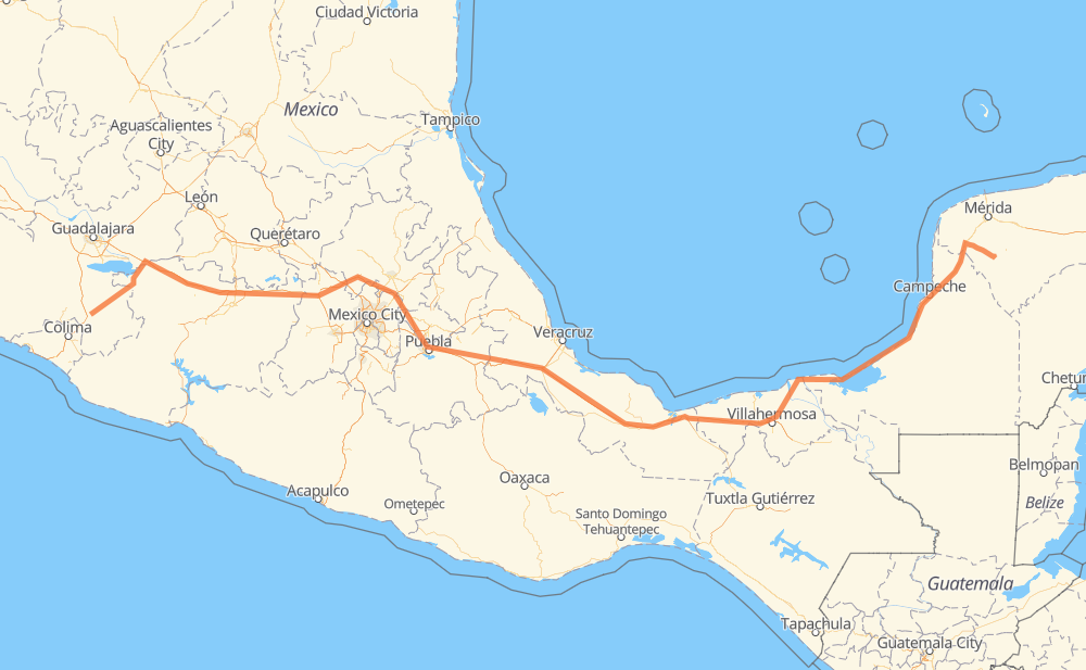
Distance between Tuxpan and Pustunich
The distance from Tuxpan to Pustunich is 1,180 miles by road including 718 miles on motorways. Road takes approximately 21 hours and 10 minutes and goes through Orizaba, Mazamitla, San José de Gracia, Jiquilpan de Juárez, Sahuayo de Morelos, San Pedro Cahro and La Barca.
| Shortest distance by air | 902 mi ✈️ |
| Car route length | 1,180 mi 🚗 |
| Driving time | 21 h 10 min |
| Fuel amount | 40.1 gal |
| Fuel cost | 157.8 USD |
| Toll roads cost | 1,283 + ? MXN |
| Point | Distance | Time | Fuel | |
| Tuxpan | 0 mi | 00 min | 0.0 gal | |
|
MEX 110 45 mi, 50 min
|
||||
| Mazamitla | 45 mi | 50 min | 1.4 gal | |
|
JAL 414 11 mi, 12 min
|
||||
| San José de Gracia | 55 mi | 1 h 02 min | 1.6 gal | |
|
MEX 110 18 mi, 21 min
|
||||
| Jiquilpan de Juárez | 73 mi | 1 h 24 min | 2.4 gal | |
|
MEX 110 5 mi, 05 min
|
||||
| Sahuayo de Morelos | 78 mi | 1 h 30 min | 2.6 gal | |
|
MEX 110 8 mi, 09 min
|
||||
| San Pedro Cahro | 86 mi | 1 h 39 min | 2.8 gal | |
|
MEX 110 14 mi, 16 min
|
||||
| La Barca | 100 mi | 1 h 56 min | 3.3 gal | |
|
MEX 71 MEX 15D 10 mi, 11 min
|
||||
| Vista Hermosa de Negrete | 110 mi | 2 h 07 min | 3.6 gal | |
|
MEX 15D 429 mi, 7 h 30 min
|
||||
| Orizaba | 539 mi | 9 h 38 min | 18.3 gal | |
|
MEX 150D MEX 180 643 mi, 11 h 31 min
|
||||
| Pustunich | 1,182 mi | 21 h 09 min | 40.2 gal | |
Frequently Asked Questions
How many toll booths are there from Tuxpan to Pustunich?
There are 21 toll booths between Tuxpan and Pustunich: Fortín, Cuitláhuac, Cosamaloapan, Acayucan, Antonio Dovali, Zinapecuaro, Contepec, Panindicuaro, Ecuandureo, Atlacomulco — Maravatio, Atlacomulco 2, San Martin Texmelucan, San Martín, Viaducto Elevado de Puebla, Amozoc, Esperanza 27, Sánchez Magallanes, Villahermosa Nacajuca, Zacatal, Unidad and Seybaplaya.
How much does the toll booths cost from Tuxpan to Pustunich?
Toll roads cost: Ecuandureo (111 MXN) + Panindicuaro (?) + Zinapecuaro (161 MXN) + Contepec (?) + Atlacomulco — Maravatio (50 MXN) + Atlacomulco 2 (?) + San Martin Texmelucan (?) + San Martín (42 MXN) + Viaducto Elevado de Puebla (?) + Amozoc (72 MXN) + Esperanza 27 (140 MXN) + Fortín (33 MXN) + Cuitláhuac (114 MXN) + Cosamaloapan (229 MXN) + Acayucan (?) + Antonio Dovali (20 MXN) + Sánchez Magallanes (82 MXN) + Villahermosa Nacajuca (62 MXN) + Zacatal (90 MXN) + Unidad (?) + Seybaplaya (77 MXN) = 1,283 + ? MXN
How much does it cost to drive from Tuxpan to Pustunich?
Fuel cost: 157.8 USD
This fuel cost is calculated as: (Route length 1,180 mi) / (Fuel consumption 29.4 mpg) * (Fuel price 3.93 USD / gal)
You can adjust fuel consumption and fuel price here.
Toll roads cost: 1,283 + ? MXN
How long is a car ride from Tuxpan to Pustunich?
Driving time: 21 h 10 min
This time is calculated for driving at the maximum permitted speed, taking into account traffic rules restrictions.
- 104 mi with a maximum speed 68 mph = 1 h 31 min
- 413 mi with a maximum speed 62 mph = 6 h 38 min
- 137 mi with a maximum speed 56 mph = 2 h 26 min
- 71 mi with a maximum speed 56 mph = 1 h 16 min
- 449 mi with a maximum speed 50 mph = 9 h 1 min
- 3 mi with a maximum speed 43 mph = 4 min
- 2 mi with a maximum speed 37 mph = 4 min
- 4 mi with a maximum speed 31 mph = 7 min
The calculated driving time does not take into account intermediate stops and traffic jams.
How far is Tuxpan to Pustunich by land?
The distance between Tuxpan and Pustunich is 1,180 mi by road including 717.7 mi on motorways.
Precise satellite coordinates of highways were used for this calculation. The start and finish points are the centers of Tuxpan and Pustunich respectively.
How far is Tuxpan to Pustunich by plane?
The shortest distance (air line, as the crow flies) between Tuxpan and Pustunich is 902.2 mi.
This distance is calculated using the Haversine formula as a great-circle distance between two points on the surface of a sphere. The start and finish points are the centers of Tuxpan and Pustunich respectively. Actual distance between airports may be different.
How many hours is Tuxpan from Pustunich by plane?
Boeing 737 airliner needs 1 h 48 min to cover the distance of 902 mi at a cruising speed of 497 mph.
Small plane "Cessna 172" needs 6 h 36 min to flight this distance at average speed of 136 mph.
This time is approximate and do not take into account takeoff and landing times, airport location and other real world factors.
How long is a helicopter ride from Tuxpan to Pustunich?
Fast helicopter "Eurocopter AS350" or "Hughes OH-6 Cayuse" need 6 h 3 min to cover the distance of 902 mi at a cruising speed of 149 mph.
Popular "Robinson R44" needs 6 h 54 min to flight this distance at average speed of 130 mph.
This time is approximate and do not take into account takeoff and landing times, aerodrome location and other real world factors.
What city is halfway between Tuxpan and Pustunich?
The halfway point between Tuxpan and Pustunich is Piedra Herrada. It is located about 3 mi from the exact midpoint by road.
The distance from Piedra Herrada to Tuxpan is 587 mi and driving will take about 10 h 22 min. The road between Piedra Herrada and Pustunich has length 593 mi and will take approximately 10 h 47 min.
The other cities located close to halfway point:
Where is Tuxpan in relation to Pustunich?
Tuxpan is located 902 mi west of Pustunich.
Tuxpan has geographic coordinates: latitude 19.55634, longitude -103.37599.
Pustunich has geographic coordinates: latitude 20.36742, longitude -89.51011.
Which highway goes from Tuxpan to Pustunich?
The route from Tuxpan to Pustunich follows MEX 180, MEX 15D, MEX 150D, MEX 145D, MEX M40D, MEX 110, MEX 180D.
Other minor sections pass along the road:
- MEX 184: 29 mi
- MEX 15: 6 mi
- MEX 040D: 4 mi
- MEX 71: 4 mi
- JAL 414: 2 mi
- MEX 35: 2 mi
- MICH 110: 1 mi