Distance between Tuxtla Gutiérrez and Nuevo Teapa (Santa Cecilia)
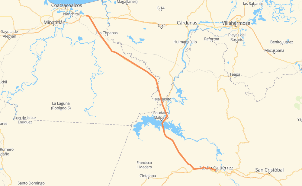
The distance from Tuxtla Gutiérrez to Nuevo Teapa (Santa Cecilia) is 142 miles by road. Road takes approximately 2 hours and 35 minutes and goes through Ocozocuautla, El Sabino, Llano Verde, San Juan de los Reyes (Los Caimanes) and Francisco Villa.
| Shortest distance by air | 119 mi ✈️ |
| Car route length | 141.7 mi 🚗 |
| Driving time | 2 h 35 min |
| Fuel amount | 4.8 gal |
| Fuel cost | 18.9 USD |
| Toll roads cost | 246 MXN |
| Point | Distance | Time | Fuel | |
| Tuxtla Gutiérrez | 0 mi | 00 min | 0.0 gal | |
|
MEX 190 10 mi, 11 min
|
||||
| El Sabino | 10 mi | 11 min | 0.2 gal | |
|
MEX 190 4 mi, 04 min
|
||||
| Ocozocuautla | 14 mi | 16 min | 0.4 gal | |
|
MEX 190 MEX 180D 88 mi, 1 h 34 min
|
||||
| Llano Verde | 102 mi | 1 h 51 min | 3.3 gal | |
|
MEX 180D 40 mi, 43 min
|
||||
| Nuevo Teapa (Santa Cecilia) | 142 mi | 2 h 34 min | 4.7 gal | |
Frequently Asked Questions
How many toll booths are there from Tuxtla Gutiérrez to Nuevo Teapa (Santa Cecilia)?
There are 3 toll booths between Tuxtla Gutiérrez and Nuevo Teapa (Santa Cecilia): Las Choapas, Ocozocoautla 182 and Malpasito.
How much does the toll booths cost from Tuxtla Gutiérrez to Nuevo Teapa (Santa Cecilia)?
Toll roads cost: Ocozocoautla 182 (82 MXN) + Malpasito (82 MXN) + Las Choapas (82 MXN) = 246 MXN
How much does it cost to drive from Tuxtla Gutiérrez to Nuevo Teapa (Santa Cecilia)?
Fuel cost: 18.9 USD
This fuel cost is calculated as: (Route length 141.7 mi) / (Fuel consumption 29.4 mpg) * (Fuel price 3.93 USD / gal)
You can adjust fuel consumption and fuel price here.
Toll roads cost: 246 MXN
How long is a car ride from Tuxtla Gutiérrez to Nuevo Teapa (Santa Cecilia)?
Driving time: 2 h 35 min
This time is calculated for driving at the maximum permitted speed, taking into account traffic rules restrictions.
- 117 mi with a maximum speed 56 mph = 2 h 5 min
- 24 mi with a maximum speed 50 mph = 29 min
The calculated driving time does not take into account intermediate stops and traffic jams.
How far is Tuxtla Gutiérrez to Nuevo Teapa (Santa Cecilia) by land?
The distance between Tuxtla Gutiérrez and Nuevo Teapa (Santa Cecilia) is 141.7 mi by road.
Precise satellite coordinates of highways were used for this calculation. The start and finish points are the centers of Tuxtla Gutiérrez and Nuevo Teapa (Santa Cecilia) respectively.
How far is Tuxtla Gutiérrez to Nuevo Teapa (Santa Cecilia) by plane?
The shortest distance (air line, as the crow flies) between Tuxtla Gutiérrez and Nuevo Teapa (Santa Cecilia) is 119.3 mi.
This distance is calculated using the Haversine formula as a great-circle distance between two points on the surface of a sphere. The start and finish points are the centers of Tuxtla Gutiérrez and Nuevo Teapa (Santa Cecilia) respectively. Actual distance between airports may be different.
How many hours is Tuxtla Gutiérrez from Nuevo Teapa (Santa Cecilia) by plane?
Boeing 737 airliner needs 14 min to cover the distance of 119 mi at a cruising speed of 497 mph.
Small plane "Cessna 172" needs 52 min to flight this distance at average speed of 136 mph.
This time is approximate and do not take into account takeoff and landing times, airport location and other real world factors.
How long is a helicopter ride from Tuxtla Gutiérrez to Nuevo Teapa (Santa Cecilia)?
Fast helicopter "Eurocopter AS350" or "Hughes OH-6 Cayuse" need 48 min to cover the distance of 119 mi at a cruising speed of 149 mph.
Popular "Robinson R44" needs 54 min to flight this distance at average speed of 130 mph.
This time is approximate and do not take into account takeoff and landing times, aerodrome location and other real world factors.
What city is halfway between Tuxtla Gutiérrez and Nuevo Teapa (Santa Cecilia)?
The halfway point between Tuxtla Gutiérrez and Nuevo Teapa (Santa Cecilia) is Llano Verde. It is located about 31 mi from the exact midpoint by road.
The distance from Llano Verde to Tuxtla Gutiérrez is 102 mi and driving will take about 1 h 51 min. The road between Llano Verde and Nuevo Teapa (Santa Cecilia) has length 40 mi and will take approximately 44 min.
Where is Tuxtla Gutiérrez in relation to Nuevo Teapa (Santa Cecilia)?
Tuxtla Gutiérrez is located 119 mi south-east of Nuevo Teapa (Santa Cecilia).
Tuxtla Gutiérrez has geographic coordinates: latitude 16.75379, longitude -93.11596.
Nuevo Teapa (Santa Cecilia) has geographic coordinates: latitude 18.07306, longitude -94.27722.
Which highway goes from Tuxtla Gutiérrez to Nuevo Teapa (Santa Cecilia)?
The route from Tuxtla Gutiérrez to Nuevo Teapa (Santa Cecilia) follows MEX 180D.
Other minor sections pass along the road:
- MEX 190: 8 mi
- MEX 180: 4 mi