Distance between Twentynine Palms CA and Little Rock KS
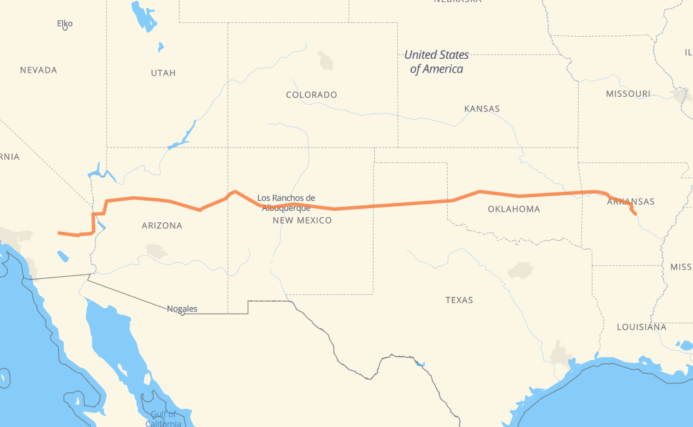
The distance from Twentynine Palms to Little Rock is 1,539 miles by road including 1,400 miles on motorways. Road takes approximately 23 hours and 15 minutes and goes through Flagstaff, Amarillo, Oklahoma City, Needles, Kingman, Winslow and Joseph City.
You can adjust fuel consumption and fuel price here.
How long is a car ride from Twentynine Palms to Little Rock?
Driving time:
23 h 15 min
This time is calculated for driving at the maximum permitted speed, taking into account traffic rules restrictions.
1,310 mi with a maximum speed 68 mph = 19 h 16 min
48 mi with a maximum speed 65 mph = 43 min
6 mi with a maximum speed 62 mph = 5 min
28 mi with a maximum speed 60 mph = 28 min
118 mi with a maximum speed 56 mph = 2 h 6 min
28 mi with a maximum speed 50 mph = 33 min
1 mi with a maximum speed 31 mph = 1 min
The calculated driving time does not take into account intermediate stops and traffic jams.
How far is Twentynine Palms to Little Rock by land?
The distance between Twentynine Palms and Little Rock is 1,539.1 mi by road including 1,399.9 mi on motorways.
Precise satellite coordinates of highways were used for this calculation. The start and finish points are the centers of Twentynine Palms and Little Rock respectively.
How far is Twentynine Palms to Little Rock by plane?
The shortest distance (air line, as the crow flies) between Twentynine Palms and Little Rock is 1,352.1 mi.
This distance is calculated using the Haversine formula as a great-circle distance between two points on the surface of a sphere. The start and finish points are the centers of Twentynine Palms and Little Rock respectively. Actual distance between airports may be different.
How many hours is Twentynine Palms from Little Rock by plane?
Boeing 737 airliner needs 2 h 43 min to cover the distance of 1,352 mi at a cruising speed of 497 mph.
Small plane "Cessna 172" needs 9 h 53 min to flight this distance at average speed of 136 mph.
This time is approximate and do not take into account takeoff and landing times, airport location and other real world factors.
How long is a helicopter ride from Twentynine Palms to Little Rock?
Fast helicopter "Eurocopter AS350" or "Hughes OH-6 Cayuse" need 9 h 4 min to cover the distance of 1,352 mi at a cruising speed of 149 mph.
Popular "Robinson R44" needs 10 h 21 min to flight this distance at average speed of 130 mph.
This time is approximate and do not take into account takeoff and landing times, aerodrome location and other real world factors.
What city is halfway between Twentynine Palms and Little Rock?
The halfway point between Twentynine Palms and Little Rock is Santa Rosa. It is located about 11 mi from the exact midpoint by road.
The distance from Santa Rosa to Twentynine Palms is 780 mi and driving will take about 11 h 57 min. The road between Santa Rosa and Little Rock has length 759 mi and will take approximately 11 h 17 min.
The other cities located close to halfway point:
Newkirk is in 797 mi from Twentynine Palms and 741 mi from Little Rock
Clines Corners is in 729 mi from Twentynine Palms and 810 mi from Little Rock
Tucumcari is in 834 mi from Twentynine Palms and 705 mi from Little Rock
Where is Twentynine Palms in relation to Little Rock?
Twentynine Palms is located 1,352 mi west of Little Rock.
Twentynine Palms has geographic coordinates: latitude 34.13568, longitude -116.05435.
Little Rock has geographic coordinates: latitude 34.74648, longitude -92.28959.
Which highway goes from Twentynine Palms to Little Rock?
The route from Twentynine Palms to Little Rock follows I 40, CA 62, US 180, US 270.