Distance between Villa Matamoros and El Naranjito
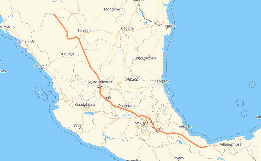
The distance from Villa Matamoros to El Naranjito is 1,122 miles by road including 660 miles on motorways. Road takes approximately 19 hours and 23 minutes and goes through Fresnillo, Aguascalientes, Salamanca, Celaya, Orizaba and Minatitlán.
| Shortest distance by air | 926 mi ✈️ |
| Car route length | 1,121.6 mi 🚗 |
| Driving time | 19 h 23 min |
| Fuel amount | 38.1 gal |
| Fuel cost | 147.2 USD |
| Toll roads cost | 1,227 + ? MXN |
| Point | Distance | Time | Fuel | |
| Villa Matamoros | 0 mi | 00 min | 0.0 gal | |
|
MEX 45 33 mi, 40 min
|
||||
| Villa Las Nieves | 33 mi | 40 min | 1.0 gal | |
|
MEX 45 8 mi, 10 min
|
||||
| Torreón de Cañas | 40 mi | 50 min | 1.4 gal | |
|
MEX 45 18 mi, 18 min
|
||||
| Revolución | 58 mi | 1 h 09 min | 1.9 gal | |
|
MEX 45 MEX 49 301 mi, 5 h 30 min
|
||||
| Fresnillo | 359 mi | 6 h 40 min | 12.0 gal | |
|
MEX 45D 111 mi, 1 h 58 min
|
||||
| Aguascalientes | 470 mi | 8 h 39 min | 15.9 gal | |
|
MEX 70 MEX 45D 127 mi, 1 h 58 min
|
||||
| Salamanca | 597 mi | 10 h 37 min | 20.3 gal | |
|
MEX 45D 19 mi, 18 min
|
||||
| Celaya | 616 mi | 10 h 56 min | 20.9 gal | |
|
MEX 45D MEX M40D 318 mi, 5 h 21 min
|
||||
| Orizaba | 934 mi | 16 h 17 min | 31.7 gal | |
|
MEX 150D MEX 145D 189 mi, 3 h 04 min
|
||||
| Minatitlán | 1,123 mi | 19 h 22 min | 38.2 gal | |
|
MEX 180 1 mi, 01 min
|
||||
| 18.00083, -94.60528 | 1,123 mi | 19 h 23 min | 38.2 gal | |
Frequently Asked Questions
How many toll booths are there from Villa Matamoros to El Naranjito?
There are 21 toll booths between Villa Matamoros and El Naranjito: Fortín, Cuitláhuac, Cosamaloapan, Acayucan, Morfín Chávez, Calera, Veta Grande, Zacatecas, Encarnacion De Diaz, León - Aguascalientes, Puerto Interior, Mendoza, Cerro Gordo, Queretaro, Palmillas, Palmilas - Apaseo, San Martin Texmelucan, San Martín, Viaducto Elevado de Puebla, Amozoc and Esperanza 27.
How much does the toll booths cost from Villa Matamoros to El Naranjito?
Toll roads cost: Morfín Chávez (40 MXN) + Calera (23 MXN) + Veta Grande (48 MXN) + Zacatecas (41 MXN) + Encarnacion De Diaz (150 MXN) + León - Aguascalientes (153 MXN) + Puerto Interior (?) + Mendoza (53 MXN) + Cerro Gordo (?) + Palmilas - Apaseo (?) + Palmillas (89 MXN) + Queretaro (?) + San Martin Texmelucan (?) + San Martín (42 MXN) + Viaducto Elevado de Puebla (?) + Amozoc (72 MXN) + Esperanza 27 (140 MXN) + Fortín (33 MXN) + Cuitláhuac (114 MXN) + Cosamaloapan (229 MXN) + Acayucan (?) = 1,227 + ? MXN
How much does it cost to drive from Villa Matamoros to El Naranjito?
Fuel cost: 147.2 USD
This fuel cost is calculated as: (Route length 1,121.6 mi) / (Fuel consumption 29.4 mpg) * (Fuel price 3.86 USD / gal)
You can adjust fuel consumption and fuel price here.
Toll roads cost: 1,227 + ? MXN
How long is a car ride from Villa Matamoros to El Naranjito?
Driving time: 19 h 23 min
This time is calculated for driving at the maximum permitted speed, taking into account traffic rules restrictions.
- 241 mi with a maximum speed 68 mph = 3 h 32 min
- 296 mi with a maximum speed 62 mph = 4 h 46 min
- 194 mi with a maximum speed 56 mph = 3 h 28 min
- 165 mi with a maximum speed 56 mph = 2 h 56 min
- 217 mi with a maximum speed 50 mph = 4 h 22 min
- 4 mi with a maximum speed 43 mph = 4 min
- 2 mi with a maximum speed 31 mph = 4 min
- 2 mi with a maximum speed 25 mph = 5 min
- 1 mi with a maximum speed 19 mph = 1 min
The calculated driving time does not take into account intermediate stops and traffic jams.
How far is Villa Matamoros to El Naranjito by land?
The distance between Villa Matamoros and El Naranjito is 1,121.6 mi by road including 659.9 mi on motorways.
Precise satellite coordinates of highways were used for this calculation. The start and finish points are the centers of Villa Matamoros and El Naranjito respectively.
How far is Villa Matamoros to El Naranjito by plane?
The shortest distance (air line, as the crow flies) between Villa Matamoros and El Naranjito is 925.8 mi.
This distance is calculated using the Haversine formula as a great-circle distance between two points on the surface of a sphere. The start and finish points are the centers of Villa Matamoros and El Naranjito respectively. Actual distance between airports may be different.
How many hours is Villa Matamoros from El Naranjito by plane?
Boeing 737 airliner needs 1 h 51 min to cover the distance of 926 mi at a cruising speed of 497 mph.
Small plane "Cessna 172" needs 6 h 46 min to flight this distance at average speed of 136 mph.
This time is approximate and do not take into account takeoff and landing times, airport location and other real world factors.
How long is a helicopter ride from Villa Matamoros to El Naranjito?
Fast helicopter "Eurocopter AS350" or "Hughes OH-6 Cayuse" need 6 h 12 min to cover the distance of 926 mi at a cruising speed of 149 mph.
Popular "Robinson R44" needs 7 h 5 min to flight this distance at average speed of 130 mph.
This time is approximate and do not take into account takeoff and landing times, aerodrome location and other real world factors.
What city is halfway between Villa Matamoros and El Naranjito?
The halfway point between Villa Matamoros and El Naranjito is La Aldea. It is located about 2 mi from the exact midpoint by road.
The distance from La Aldea to Villa Matamoros is 563 mi and driving will take about 10 h 4 min. The road between La Aldea and El Naranjito has length 558 mi and will take approximately 9 h 19 min.
The other cities located close to halfway point:
Where is Villa Matamoros in relation to El Naranjito?
Villa Matamoros is located 926 mi north-west of El Naranjito.
Villa Matamoros has geographic coordinates: latitude 26.76449, longitude -105.58471.
El Naranjito has geographic coordinates: latitude 18.00083, longitude -94.60528.
Which highway goes from Villa Matamoros to El Naranjito?
The route from Villa Matamoros to El Naranjito follows MEX 45, MEX 45D, MEX 150D, MEX 49, MEX 145D, MEX M40D.
Other minor sections pass along the road:
- MEX 34: 60 mi
- MEX 47D: 52 mi
- MEX 43D: 48 mi
- MEX 57D: 35 mi
- MEX 70: 33 mi
- MEX 40: 14 mi
- MEX 180: 1 mi
- MEX 54: 1 mi