Distance between Villefranche-sur-Saône and Saint-Hilaire-de-Riez
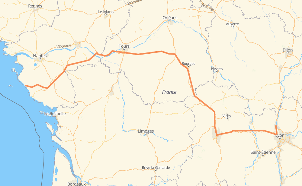
The distance from Villefranche-sur-Saône to Saint-Hilaire-de-Riez is 457 miles by road including 377 miles on motorways. Road takes approximately 7 hours and 13 minutes and goes through Clermont-Ferrand, Tarare, Thiers, Riom, Bourges, Vierzon and Joué-lès-Tours.
You can adjust fuel consumption and fuel price here.
How long is a car ride from Villefranche-sur-Saône to Saint-Hilaire-de-Riez?
Driving time:
7 h 13 min
This time is calculated for driving at the maximum permitted speed, taking into account traffic rules restrictions.
359 mi with a maximum speed 68 mph = 5 h 16 min
3 mi with a maximum speed 62 mph = 3 min
26 mi with a maximum speed 56 mph = 27 min
13 mi with a maximum speed 56 mph = 14 min
47 mi with a maximum speed 50 mph = 56 min
5 mi with a maximum speed 43 mph = 7 min
4 mi with a maximum speed 31 mph = 7 min
1 mi with a maximum speed 19 mph = 2 min
The calculated driving time does not take into account intermediate stops and traffic jams.
How far is Villefranche-sur-Saône to Saint-Hilaire-de-Riez by land?
The distance between Villefranche-sur-Saône and Saint-Hilaire-de-Riez is 456.7 mi by road including 377.2 mi on motorways.
Precise satellite coordinates of highways were used for this calculation. The start and finish points are the centers of Villefranche-sur-Saône and Saint-Hilaire-de-Riez respectively.
How far is Villefranche-sur-Saône to Saint-Hilaire-de-Riez by plane?
The shortest distance (air line, as the crow flies) between Villefranche-sur-Saône and Saint-Hilaire-de-Riez is 321.9 mi.
This distance is calculated using the Haversine formula as a great-circle distance between two points on the surface of a sphere. The start and finish points are the centers of Villefranche-sur-Saône and Saint-Hilaire-de-Riez respectively. Actual distance between airports may be different.
How many hours is Villefranche-sur-Saône from Saint-Hilaire-de-Riez by plane?
Boeing 737 airliner needs 38 min to cover the distance of 322 mi at a cruising speed of 497 mph.
Small plane "Cessna 172" needs 2 h 21 min to flight this distance at average speed of 136 mph.
This time is approximate and do not take into account takeoff and landing times, airport location and other real world factors.
How long is a helicopter ride from Villefranche-sur-Saône to Saint-Hilaire-de-Riez?
Fast helicopter "Eurocopter AS350" or "Hughes OH-6 Cayuse" need 2 h 9 min to cover the distance of 322 mi at a cruising speed of 149 mph.
Popular "Robinson R44" needs 2 h 28 min to flight this distance at average speed of 130 mph.
This time is approximate and do not take into account takeoff and landing times, aerodrome location and other real world factors.
What city is halfway between Villefranche-sur-Saône and Saint-Hilaire-de-Riez?
The halfway point between Villefranche-sur-Saône and Saint-Hilaire-de-Riez is Vierzon. It is located about 1 mi from the exact midpoint by road.
The distance from Vierzon to Villefranche-sur-Saône is 228 mi and driving will take about 3 h 24 min. The road between Vierzon and Saint-Hilaire-de-Riez has length 229 mi and will take approximately 3 h 49 min.
The other cities located close to halfway point:
Givry is in 223 mi from Villefranche-sur-Saône and 234 mi from Saint-Hilaire-de-Riez
La Chevalerie is in 220 mi from Villefranche-sur-Saône and 237 mi from Saint-Hilaire-de-Riez
Bourges is in 208 mi from Villefranche-sur-Saône and 249 mi from Saint-Hilaire-de-Riez
Where is Villefranche-sur-Saône in relation to Saint-Hilaire-de-Riez?
Villefranche-sur-Saône is located 322 mi east of Saint-Hilaire-de-Riez.
Villefranche-sur-Saône has geographic coordinates: latitude 45.98647, longitude 4.72661.
Saint-Hilaire-de-Riez has geographic coordinates: latitude 46.72194, longitude -1.94417.
Which highway goes from Villefranche-sur-Saône to Saint-Hilaire-de-Riez?
The route from Villefranche-sur-Saône to Saint-Hilaire-de-Riez follows A 71, A 85, A 89.