Distance between Virginia City MT and Encinitas CA
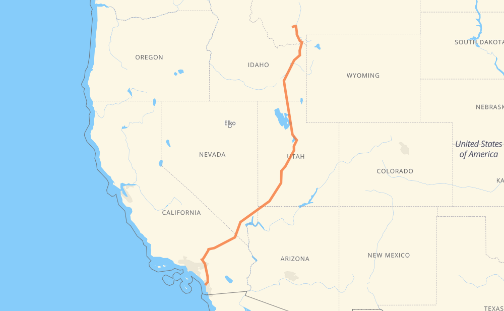
The distance from Virginia City to Encinitas is 1,110 miles by road including 959 miles on motorways. Road takes approximately 17 hours and 28 minutes and goes through Idaho Falls, Pocatello, Ogden, Salt Lake City, Provo, St. George and North Las Vegas.
| Shortest distance by air | 894 mi ✈️ |
| Car route length | 1,110.4 mi 🚗 |
| Driving time | 17 h 28 min |
| Fuel amount | 37.8 gal |
| Fuel cost | 147.3 USD |
| Point | Distance | Time | Fuel | |
| Virginia City | 0 mi | 00 min | 0.0 gal | |
|
MT 287 US 20 167 mi, 3 h 06 min
|
||||
| Idaho Falls | 167 mi | 3 h 06 min | 5.5 gal | |
|
US 20 I 15 52 mi, 53 min
|
||||
| Pocatello | 218 mi | 4 h 00 min | 7.3 gal | |
|
I 15 126 mi, 1 h 58 min
|
||||
| Ogden | 344 mi | 5 h 58 min | 11.6 gal | |
|
I 15 34 mi, 29 min
|
||||
| Salt Lake City | 378 mi | 6 h 28 min | 12.7 gal | |
|
I 15 46 mi, 40 min
|
||||
| Provo | 423 mi | 7 h 08 min | 14.2 gal | |
|
I 15 258 mi, 3 h 48 min
|
||||
| St. George | 682 mi | 10 h 57 min | 23.0 gal | |
|
I 15 107 mi, 1 h 36 min
|
||||
| North Las Vegas | 789 mi | 12 h 34 min | 26.6 gal | |
|
I 15 9 mi, 07 min
|
||||
| Las Vegas | 798 mi | 12 h 41 min | 27.1 gal | |
|
I 15 189 mi, 2 h 47 min
|
||||
| Victorville | 986 mi | 15 h 29 min | 33.3 gal | |
|
I 15 31 mi, 27 min
|
||||
| San Bernardino | 1,018 mi | 15 h 57 min | 34.4 gal | |
|
I 215 16 mi, 14 min
|
||||
| Riverside | 1,033 mi | 16 h 11 min | 35.0 gal | |
|
I 215 23 mi, 21 min
|
||||
| Menifee | 1,056 mi | 16 h 33 min | 35.8 gal | |
|
I 215 7 mi, 06 min
|
||||
| Murrieta | 1,063 mi | 16 h 39 min | 36.0 gal | |
|
I 215 7 mi, 06 min
|
||||
| Temecula | 1,070 mi | 16 h 46 min | 36.3 gal | |
|
I 15 52 mi, 56 min
|
||||
| Encinitas | 1,122 mi | 17 h 42 min | 37.5 gal | |
Hotels of Encinitas
Frequently Asked Questions
How much does it cost to drive from Virginia City to Encinitas?
Fuel cost: 147.3 USD
This fuel cost is calculated as: (Route length 1,110.4 mi) / (Fuel consumption 29.4 mpg) * (Fuel price 3.9 USD / gal)
You can adjust fuel consumption and fuel price here.
How long is a car ride from Virginia City to Encinitas?
Driving time: 17 h 28 min
This time is calculated for driving at the maximum permitted speed, taking into account traffic rules restrictions.
- 736 mi with a maximum speed 68 mph = 10 h 49 min
- 76 mi with a maximum speed 65 mph = 1 h 9 min
- 76 mi with a maximum speed 62 mph = 1 h 13 min
- 4 mi with a maximum speed 60 mph = 4 min
- 89 mi with a maximum speed 56 mph = 1 h 35 min
- 15 mi with a maximum speed 55 mph = 15 min
- 1 mi with a maximum speed 50 mph = 1 min
- 105 mi with a maximum speed 50 mph = 2 h 6 min
- 6 mi with a maximum speed 45 mph = 7 min
- 1 mi with a maximum speed 40 mph = 1 min
- 1 mi with a maximum speed 30 mph = 1 min
- 1 mi with a maximum speed 25 mph = 1 min
The calculated driving time does not take into account intermediate stops and traffic jams.
How far is Virginia City to Encinitas by land?
The distance between Virginia City and Encinitas is 1,110.4 mi by road including 958.8 mi on motorways.
Precise satellite coordinates of highways were used for this calculation. The start and finish points are the centers of Virginia City and Encinitas respectively.
How far is Virginia City to Encinitas by plane?
The shortest distance (air line, as the crow flies) between Virginia City and Encinitas is 893.5 mi.
This distance is calculated using the Haversine formula as a great-circle distance between two points on the surface of a sphere. The start and finish points are the centers of Virginia City and Encinitas respectively. Actual distance between airports may be different.
How many hours is Virginia City from Encinitas by plane?
Boeing 737 airliner needs 1 h 47 min to cover the distance of 894 mi at a cruising speed of 497 mph.
Small plane "Cessna 172" needs 6 h 32 min to flight this distance at average speed of 136 mph.
This time is approximate and do not take into account takeoff and landing times, airport location and other real world factors.
How long is a helicopter ride from Virginia City to Encinitas?
Fast helicopter "Eurocopter AS350" or "Hughes OH-6 Cayuse" need 5 h 59 min to cover the distance of 894 mi at a cruising speed of 149 mph.
Popular "Robinson R44" needs 6 h 50 min to flight this distance at average speed of 130 mph.
This time is approximate and do not take into account takeoff and landing times, aerodrome location and other real world factors.
What city is halfway between Virginia City and Encinitas?
The halfway point between Virginia City and Encinitas is Beaver. It is located about 21 mi from the exact midpoint by road.
The distance from Beaver to Virginia City is 576 mi and driving will take about 9 h 22 min. The road between Beaver and Encinitas has length 534 mi and will take approximately 8 h 5 min.
The other cities located close to halfway point:
Where is Virginia City in relation to Encinitas?
Virginia City is located 894 mi north-east of Encinitas.
Virginia City has geographic coordinates: latitude 45.2938, longitude -111.94612.
Encinitas has geographic coordinates: latitude 33.03699, longitude -117.29198.
Which highway goes from Virginia City to Encinitas?
The route from Virginia City to Encinitas follows I 15, US 20.
Other minor sections pass along the road:
- I 215: 55 mi
- US 287: 40 mi
- I 84: 38 mi
- US 91: 30 mi
- US 26: 23 mi
- US 93: 21 mi
- US 30: 19 mi
- MT 287: 14 mi
- US 89: 14 mi
- US 6: 12 mi
- S10: 11 mi
- US 50: 9 mi
- ID 87: 9 mi
- MT 87: 9 mi
- S12: 8 mi
- UT 30: 5 mi
- CA 60: 4 mi
- CA 79: 2 mi
- CA 18: 2 mi
- I 80: 2 mi
- CA 74: 2 mi
- I 215 Truck: 1 mi
- S21: 1 mi