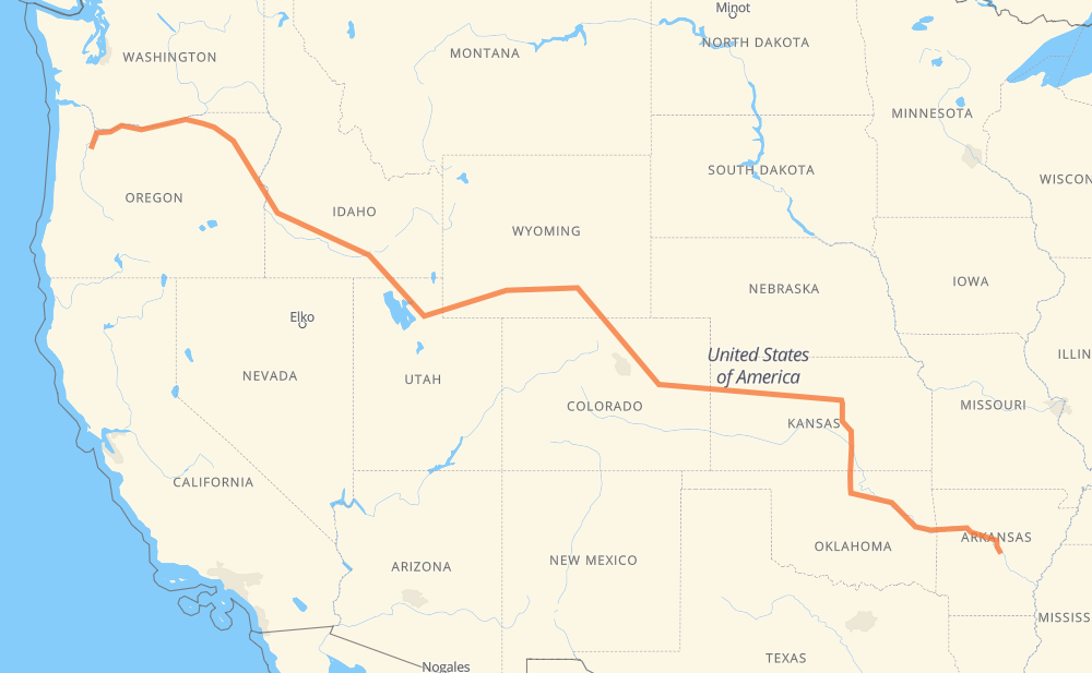
The distance from Woodburn to Little Rock is 2,242 miles by road including 2,239 miles on motorways. Road takes approximately 33 hours and 59 minutes and goes through Portland, Ogden, Rock Springs, Laramie, Cheyenne, Denver and Wichita.
You can adjust fuel consumption and fuel price here.
How long is a car ride from Woodburn to Little Rock?
Driving time:
33 h 59 min
This time is calculated for driving at the maximum permitted speed, taking into account traffic rules restrictions.
1,799 mi with a maximum speed 68 mph = 26 h 26 min
151 mi with a maximum speed 65 mph = 2 h 19 min
142 mi with a maximum speed 62 mph = 2 h 16 min
25 mi with a maximum speed 60 mph = 25 min
21 mi with a maximum speed 55 mph = 22 min
4 mi with a maximum speed 50 mph = 5 min
99 mi with a maximum speed 50 mph = 1 h 59 min
1 mi with a maximum speed 31 mph = 1 min
The calculated driving time does not take into account intermediate stops and traffic jams.
How far is Woodburn to Little Rock by land?
The distance between Woodburn and Little Rock is 2,241.9 mi by road including 2,238.8 mi on motorways.
Precise satellite coordinates of highways were used for this calculation. The start and finish points are the centers of Woodburn and Little Rock respectively.
How far is Woodburn to Little Rock by plane?
The shortest distance (air line, as the crow flies) between Woodburn and Little Rock is 1,757.9 mi.
This distance is calculated using the Haversine formula as a great-circle distance between two points on the surface of a sphere. The start and finish points are the centers of Woodburn and Little Rock respectively. Actual distance between airports may be different.
How many hours is Woodburn from Little Rock by plane?
Boeing 737 airliner needs 3 h 32 min to cover the distance of 1,758 mi at a cruising speed of 497 mph.
Small plane "Cessna 172" needs 12 h 51 min to flight this distance at average speed of 136 mph.
This time is approximate and do not take into account takeoff and landing times, airport location and other real world factors.
How long is a helicopter ride from Woodburn to Little Rock?
Fast helicopter "Eurocopter AS350" or "Hughes OH-6 Cayuse" need 11 h 47 min to cover the distance of 1,758 mi at a cruising speed of 149 mph.
Popular "Robinson R44" needs 13 h 28 min to flight this distance at average speed of 130 mph.
This time is approximate and do not take into account takeoff and landing times, aerodrome location and other real world factors.
What city is halfway between Woodburn and Little Rock?
The halfway point between Woodburn and Little Rock is Laramie. It is located about 21 mi from the exact midpoint by road.
The distance from Laramie to Woodburn is 1,143 mi and driving will take about 17 h 39 min. The road between Laramie and Little Rock has length 1,100 mi and will take approximately 16 h 19 min.
The other cities located close to halfway point:
PhinDeli Town Buford is in 1,167 mi from Woodburn and 1,076 mi from Little Rock
Granite is in 1,174 mi from Woodburn and 1,069 mi from Little Rock
Cheyenne is in 1,189 mi from Woodburn and 1,053 mi from Little Rock
Where is Woodburn in relation to Little Rock?
Woodburn is located 1,758 mi north-west of Little Rock.
Woodburn has geographic coordinates: latitude 45.14373, longitude -122.85537.
Little Rock has geographic coordinates: latitude 34.74648, longitude -92.28959.
Which highway goes from Woodburn to Little Rock?
The route from Woodburn to Little Rock follows I 84, US 30, I 70, I 80, I 40, US 40, I 135, US 81, US 26, I 35, I 25, US 412.