Distance between Xicotepec de Juárez and Zihuatanejo
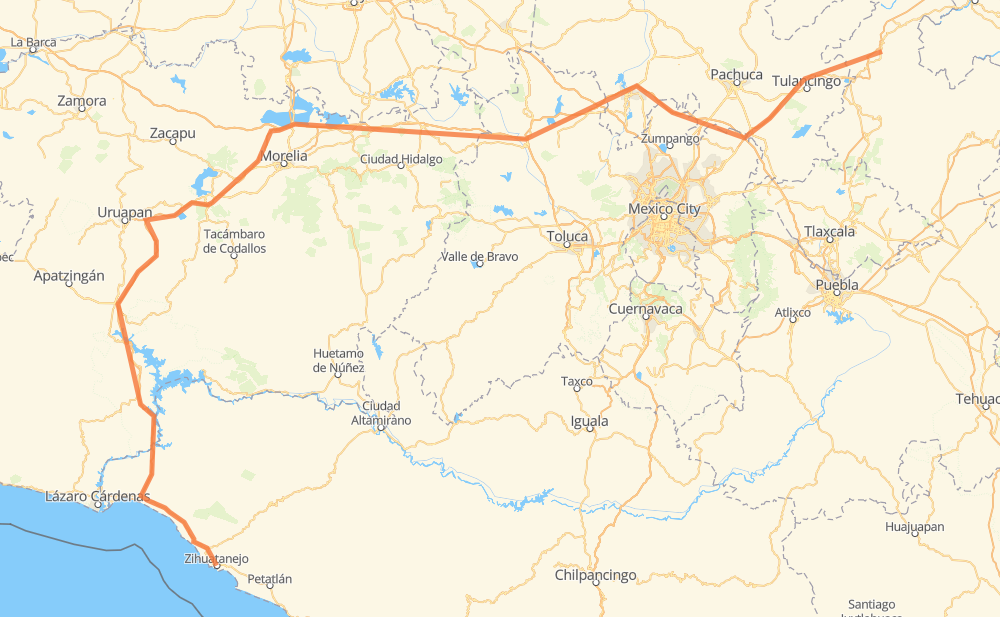
The distance from Xicotepec de Juárez to Zihuatanejo is 479 miles by road including 336 miles on motorways. Road takes approximately 8 hours and 21 minutes and goes through Santiago Tolman, San Miguel Atepoxco, Jilotepec de Molina Enriquez, Pastores, Pátzcuaro, Ziracuaretiro and Nueva Italia de Ruíz.
| Shortest distance by air | 297 mi ✈️ |
| Car route length | 479.1 mi 🚗 |
| Driving time | 8 h 21 min |
| Fuel amount | 16.3 gal |
| Fuel cost | 63.5 USD |
| Toll roads cost | 318 + ? MXN |
| Point | Distance | Time | Fuel | |
| Xicotepec de Juárez | 0 mi | 00 min | 0.0 gal | |
|
MEX 130 16 mi, 19 min
|
||||
| Xilocuautla | 16 mi | 19 min | 0.5 gal | |
|
MEX 130D 14 mi, 16 min
|
||||
| Tlacpac | 30 mi | 35 min | 1.0 gal | |
|
MEX 130D 32 mi, 35 min
|
||||
| Singuilucan | 62 mi | 1 h 11 min | 1.8 gal | |
|
MEX 132 8 mi, 09 min
|
||||
| Santiago Tolman | 70 mi | 1 h 20 min | 2.4 gal | |
|
MEX 132 MEX M40D 64 mi, 1 h 04 min
|
||||
| Jilotepec de Molina Enriquez | 134 mi | 2 h 25 min | 4.4 gal | |
|
MEX M40D MEX 15D 163 mi, 2 h 45 min
|
||||
| Pátzcuaro | 298 mi | 5 h 10 min | 10.0 gal | |
|
MEX 14D 22 mi, 20 min
|
||||
| Ziracuaretiro | 319 mi | 5 h 31 min | 10.8 gal | |
|
MEX 14D MEX 37D 37 mi, 39 min
|
||||
| Nueva Italia de Ruíz | 357 mi | 6 h 10 min | 12.1 gal | |
|
MEX 37D 122 mi, 2 h 10 min
|
||||
| Zihuatanejo | 479 mi | 8 h 20 min | 16.2 gal | |
Hotels of Zihuatanejo
Frequently Asked Questions
How many toll booths are there from Xicotepec de Juárez to Zihuatanejo?
There are 15 toll booths between Xicotepec de Juárez and Zihuatanejo: Feliciano, Las Cañas, Santa Casilda, Taretan, Zurumucapio, Zirahuen, Cuto, Zinapecuaro, Contepec, Tulancingo, Asuncion, Atlacomulco — Maravatio, Atlacomulco 2 and Copandaro.
How much does the toll booths cost from Xicotepec de Juárez to Zihuatanejo?
Toll roads cost: Asuncion (92 MXN) + Tulancingo (?) + Atlacomulco 2 (?) + Atlacomulco — Maravatio (50 MXN) + Contepec (?) + Zinapecuaro (161 MXN) + Copandaro (15 MXN) + Cuto (?) + Zirahuen (?) + Zurumucapio (?) + Taretan (?) + Santa Casilda (?) + Las Cañas (?) + Feliciano (?) + Feliciano (?) = 318 + ? MXN
How much does it cost to drive from Xicotepec de Juárez to Zihuatanejo?
Fuel cost: 63.5 USD
This fuel cost is calculated as: (Route length 479.1 mi) / (Fuel consumption 29.4 mpg) * (Fuel price 3.9 USD / gal)
You can adjust fuel consumption and fuel price here.
Toll roads cost: 318 + ? MXN
How long is a car ride from Xicotepec de Juárez to Zihuatanejo?
Driving time: 8 h 21 min
This time is calculated for driving at the maximum permitted speed, taking into account traffic rules restrictions.
- 75 mi with a maximum speed 68 mph = 1 h 5 min
- 165 mi with a maximum speed 62 mph = 2 h 39 min
- 109 mi with a maximum speed 56 mph = 1 h 56 min
- 4 mi with a maximum speed 56 mph = 4 min
- 124 mi with a maximum speed 50 mph = 2 h 29 min
- 1 mi with a maximum speed 37 mph = 1 min
- 1 mi with a maximum speed 31 mph = 2 min
The calculated driving time does not take into account intermediate stops and traffic jams.
How far is Xicotepec de Juárez to Zihuatanejo by land?
The distance between Xicotepec de Juárez and Zihuatanejo is 479.1 mi by road including 336.2 mi on motorways.
Precise satellite coordinates of highways were used for this calculation. The start and finish points are the centers of Xicotepec de Juárez and Zihuatanejo respectively.
How far is Xicotepec de Juárez to Zihuatanejo by plane?
The shortest distance (air line, as the crow flies) between Xicotepec de Juárez and Zihuatanejo is 297 mi.
This distance is calculated using the Haversine formula as a great-circle distance between two points on the surface of a sphere. The start and finish points are the centers of Xicotepec de Juárez and Zihuatanejo respectively. Actual distance between airports may be different.
How many hours is Xicotepec de Juárez from Zihuatanejo by plane?
Boeing 737 airliner needs 35 min to cover the distance of 297 mi at a cruising speed of 497 mph.
Small plane "Cessna 172" needs 2 h 10 min to flight this distance at average speed of 136 mph.
This time is approximate and do not take into account takeoff and landing times, airport location and other real world factors.
How long is a helicopter ride from Xicotepec de Juárez to Zihuatanejo?
Fast helicopter "Eurocopter AS350" or "Hughes OH-6 Cayuse" need 1 h 59 min to cover the distance of 297 mi at a cruising speed of 149 mph.
Popular "Robinson R44" needs 2 h 16 min to flight this distance at average speed of 130 mph.
This time is approximate and do not take into account takeoff and landing times, aerodrome location and other real world factors.
What city is halfway between Xicotepec de Juárez and Zihuatanejo?
The halfway point between Xicotepec de Juárez and Zihuatanejo is Capula. It is located about 37 mi from the exact midpoint by road.
The distance from Capula to Xicotepec de Juárez is 277 mi and driving will take about 4 h 48 min. The road between Capula and Zihuatanejo has length 203 mi and will take approximately 3 h 33 min.
The other cities located close to halfway point:
Where is Xicotepec de Juárez in relation to Zihuatanejo?
Xicotepec de Juárez is located 297 mi north-east of Zihuatanejo.
Xicotepec de Juárez has geographic coordinates: latitude 20.27417, longitude -97.955.
Zihuatanejo has geographic coordinates: latitude 17.64389, longitude -101.55472.
Which highway goes from Xicotepec de Juárez to Zihuatanejo?
The route from Xicotepec de Juárez to Zihuatanejo follows MEX 37D, MEX 15D, MEX M40D.
Other minor sections pass along the road:
- MEX 130D: 35 mi
- MEX 14D: 28 mi
- MEX 200: 27 mi
- MEX 132: 24 mi
- MEX 130: 9 mi
- MEX 040D: 4 mi