Distance between Zona Centro and General Enrique Estrada
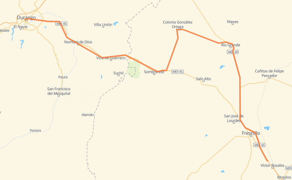
The distance from Zona Centro to General Enrique Estrada is 203 miles by road including 12 miles on motorways. Road takes approximately 3 hours and 43 minutes and goes through Durango, Fresnillo, Nombre de Dios, Vicente Guerrero, Sombrerete and Río Grande.
| Shortest distance by air | 142 mi ✈️ |
| Car route length | 202.6 mi 🚗 |
| Driving time | 3 h 43 min |
| Fuel amount | 6.9 gal |
| Fuel cost | 27 USD |
| Toll roads cost | 40 MXN |
| Point | Distance | Time | Fuel | |
| Durango | 0 mi | 00 min | 0.0 gal | |
|
MEX 45 11 mi, 15 min
|
||||
| Belisario Dominguez | 11 mi | 15 min | 0.3 gal | |
|
MEX 45 24 mi, 25 min
|
||||
| Nombre de Dios | 34 mi | 40 min | 1.1 gal | |
|
MEX 45 8 mi, 08 min
|
||||
| Amado Nervo | 42 mi | 49 min | 1.2 gal | |
|
MEX 45 9 mi, 10 min
|
||||
| El Ancón | 51 mi | 1 h 00 min | 1.7 gal | |
|
MEX 45 5 mi, 05 min
|
||||
| Vicente Guerrero | 56 mi | 1 h 05 min | 1.8 gal | |
|
MEX 45 22 mi, 23 min
|
||||
| Sombrerete | 78 mi | 1 h 29 min | 2.4 gal | |
|
MEX 45 ZAC 86 59 mi, 1 h 06 min
|
||||
| Río Grande | 137 mi | 2 h 36 min | 4.5 gal | |
|
MEX 49 49 mi, 51 min
|
||||
| Fresnillo | 187 mi | 3 h 27 min | 6.1 gal | |
|
MEX 45D MEX 45 16 mi, 15 min
|
||||
| General Enrique Estrada | 203 mi | 3 h 43 min | 6.8 gal | |
Frequently Asked Questions
How many toll booths are there from Zona Centro to General Enrique Estrada?
There are 1 tollbooth between Zona Centro and General Enrique Estrada: Morfín Chávez.
How much does the toll booths cost from Zona Centro to General Enrique Estrada?
Toll roads cost: Morfín Chávez (40 MXN) = 40 MXN
How much does it cost to drive from Zona Centro to General Enrique Estrada?
Fuel cost: 27 USD
This fuel cost is calculated as: (Route length 202.6 mi) / (Fuel consumption 29.4 mpg) * (Fuel price 3.93 USD / gal)
You can adjust fuel consumption and fuel price here.
Toll roads cost: 40 MXN
How long is a car ride from Zona Centro to General Enrique Estrada?
Driving time: 3 h 43 min
This time is calculated for driving at the maximum permitted speed, taking into account traffic rules restrictions.
- 12 mi with a maximum speed 68 mph = 10 min
- 93 mi with a maximum speed 56 mph = 1 h 39 min
- 65 mi with a maximum speed 56 mph = 1 h 9 min
- 27 mi with a maximum speed 50 mph = 31 min
- 2 mi with a maximum speed 37 mph = 4 min
- 3 mi with a maximum speed 25 mph = 7 min
The calculated driving time does not take into account intermediate stops and traffic jams.
How far is Zona Centro to General Enrique Estrada by land?
The distance between Zona Centro and General Enrique Estrada is 202.6 mi by road including 12.4 mi on motorways.
Precise satellite coordinates of highways were used for this calculation. The start and finish points are the centers of Zona Centro and General Enrique Estrada respectively.
How far is Zona Centro to General Enrique Estrada by plane?
The shortest distance (air line, as the crow flies) between Zona Centro and General Enrique Estrada is 141.7 mi.
This distance is calculated using the Haversine formula as a great-circle distance between two points on the surface of a sphere. The start and finish points are the centers of Zona Centro and General Enrique Estrada respectively. Actual distance between airports may be different.
How many hours is Zona Centro from General Enrique Estrada by plane?
Boeing 737 airliner needs 17 min to cover the distance of 142 mi at a cruising speed of 497 mph.
Small plane "Cessna 172" needs 1 h 2 min to flight this distance at average speed of 136 mph.
This time is approximate and do not take into account takeoff and landing times, airport location and other real world factors.
How long is a helicopter ride from Zona Centro to General Enrique Estrada?
Fast helicopter "Eurocopter AS350" or "Hughes OH-6 Cayuse" need 57 min to cover the distance of 142 mi at a cruising speed of 149 mph.
Popular "Robinson R44" needs 1 h 5 min to flight this distance at average speed of 130 mph.
This time is approximate and do not take into account takeoff and landing times, aerodrome location and other real world factors.
What city is halfway between Zona Centro and General Enrique Estrada?
The halfway point between Zona Centro and General Enrique Estrada is Emiliano Zapata. It is located about 4 mi from the exact midpoint by road.
The distance from Emiliano Zapata to Zona Centro is 96 mi and driving will take about 1 h 49 min. The road between Emiliano Zapata and General Enrique Estrada has length 106 mi and will take approximately 1 h 54 min.
The other cities located close to halfway point:
Where is Zona Centro in relation to General Enrique Estrada?
Zona Centro is located 142 mi north-west of General Enrique Estrada.
Zona Centro has geographic coordinates: latitude 24.02642, longitude -104.67052.
General Enrique Estrada has geographic coordinates: latitude 22.99514, longitude -102.74018.
Which highway goes from Zona Centro to General Enrique Estrada?
The route from Zona Centro to General Enrique Estrada follows MEX 45.
Other minor sections pass along the road:
- MEX 49: 42 mi
- ZAC 86: 25 mi
- ZAC 125: 24 mi
- MEX 45D: 12 mi