Distance between Bruderheim AB and Wiarton ON
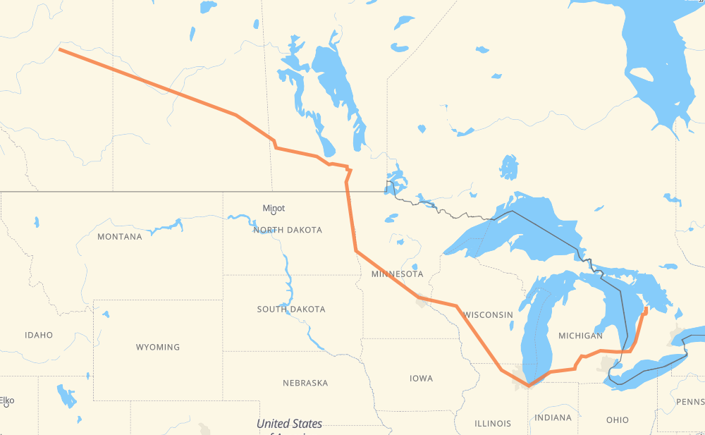
The distance from Bruderheim to Wiarton is 2,161 miles by road including 1,176 miles on motorways. Road takes approximately 36 hours and 34 minutes and goes through Lloydminster, North Battleford, Saskatoon, Yorkton, Portage la Prairie, Winnipeg and Grand Forks.
| Shortest distance by air | 1,548 mi ✈️ |
| Car route length | 2,161.1 mi 🚗 |
| Driving time | 36 h 34 min |
| Fuel amount | 73.5 gal |
| Fuel cost | 286.7 USD |
| Point | Distance | Time | Fuel | |
| Bruderheim | 0 mi | 00 min | 0.0 gal | |
|
45 16 135 mi, 2 h 27 min
|
||||
| Lloydminster | 135 mi | 2 h 27 min | 3.8 gal | |
|
16 73 mi, 1 h 19 min
|
||||
| North Battleford | 208 mi | 3 h 47 min | 6.5 gal | |
|
16 101 mi, 1 h 50 min
|
||||
| Saskatoon | 308 mi | 5 h 38 min | 10.3 gal | |
|
16 202 mi, 3 h 37 min
|
||||
| Yorkton | 510 mi | 9 h 15 min | 17.2 gal | |
|
16 PTH 16 229 mi, 4 h 14 min
|
||||
| Portage la Prairie | 739 mi | 13 h 29 min | 25.0 gal | |
|
PTH 1 53 mi, 58 min
|
||||
| Winnipeg | 792 mi | 14 h 28 min | 26.6 gal | |
|
PTH 100 I 29 142 mi, 2 h 34 min
|
||||
| Grand Forks | 933 mi | 17 h 02 min | 31.6 gal | |
|
I 29 74 mi, 1 h 17 min
|
||||
| Fargo | 1,008 mi | 18 h 20 min | 34.1 gal | |
|
I 29 I 94 327 mi, 5 h 03 min
|
||||
| Eau Claire | 1,335 mi | 23 h 23 min | 45.1 gal | |
|
I 94 175 mi, 2 h 35 min
|
||||
| Madison | 1,510 mi | 25 h 58 min | 51.2 gal | |
|
I 39 35 mi, 30 min
|
||||
| Janesville | 1,545 mi | 26 h 29 min | 52.4 gal | |
|
I 39 I 90 107 mi, 1 h 39 min
|
||||
| Chicago | 1,652 mi | 28 h 09 min | 55.7 gal | |
|
I 90 I 94 144 mi, 2 h 12 min
|
||||
| Kalamazoo | 1,796 mi | 30 h 22 min | 61.1 gal | |
|
I 94 I 69 65 mi, 56 min
|
||||
| Lansing | 1,860 mi | 31 h 19 min | 63.3 gal | |
|
I 69 62 mi, 54 min
|
||||
| Flint | 1,923 mi | 32 h 13 min | 65.3 gal | |
|
I 69 76 mi, 1 h 14 min
|
||||
| Sarnia | 1,998 mi | 33 h 28 min | 67.8 gal | |
|
402 21 163 mi, 3 h 05 min
|
||||
| Wiarton | 2,161 mi | 36 h 34 min | 73.4 gal | |
Frequently Asked Questions
How much does it cost to drive from Bruderheim to Wiarton?
Fuel cost: 286.7 USD
This fuel cost is calculated as: (Route length 2,161.1 mi) / (Fuel consumption 29.4 mpg) * (Fuel price 3.9 USD / gal)
You can adjust fuel consumption and fuel price here.
How long is a car ride from Bruderheim to Wiarton?
Driving time: 36 h 34 min
This time is calculated for driving at the maximum permitted speed, taking into account traffic rules restrictions.
- 789 mi with a maximum speed 68 mph = 11 h 35 min
- 17 mi with a maximum speed 65 mph = 15 min
- 208 mi with a maximum speed 62 mph = 3 h 20 min
- 21 mi with a maximum speed 60 mph = 20 min
- 808 mi with a maximum speed 56 mph = 14 h 26 min
- 12 mi with a maximum speed 56 mph = 13 min
- 25 mi with a maximum speed 55 mph = 27 min
- 249 mi with a maximum speed 50 mph = 5 h
- 8 mi with a maximum speed 45 mph = 10 min
- 6 mi with a maximum speed 43 mph = 8 min
- 6 mi with a maximum speed 37 mph = 10 min
- 1 mi with a maximum speed 35 mph = 1 min
- 11 mi with a maximum speed 31 mph = 20 min
- 1 mi with a maximum speed 25 mph = 2 min
The calculated driving time does not take into account intermediate stops and traffic jams.
How far is Bruderheim to Wiarton by land?
The distance between Bruderheim and Wiarton is 2,161.1 mi by road including 1,175.6 mi on motorways.
Precise satellite coordinates of highways were used for this calculation. The start and finish points are the centers of Bruderheim and Wiarton respectively.
How far is Bruderheim to Wiarton by plane?
The shortest distance (air line, as the crow flies) between Bruderheim and Wiarton is 1,547.8 mi.
This distance is calculated using the Haversine formula as a great-circle distance between two points on the surface of a sphere. The start and finish points are the centers of Bruderheim and Wiarton respectively. Actual distance between airports may be different.
How many hours is Bruderheim from Wiarton by plane?
Boeing 737 airliner needs 3 h 6 min to cover the distance of 1,548 mi at a cruising speed of 497 mph.
Small plane "Cessna 172" needs 11 h 19 min to flight this distance at average speed of 136 mph.
This time is approximate and do not take into account takeoff and landing times, airport location and other real world factors.
How long is a helicopter ride from Bruderheim to Wiarton?
Fast helicopter "Eurocopter AS350" or "Hughes OH-6 Cayuse" need 10 h 22 min to cover the distance of 1,548 mi at a cruising speed of 149 mph.
Popular "Robinson R44" needs 11 h 51 min to flight this distance at average speed of 130 mph.
This time is approximate and do not take into account takeoff and landing times, aerodrome location and other real world factors.
What city is halfway between Bruderheim and Wiarton?
The halfway point between Bruderheim and Wiarton is Fergus Falls. It is located about 12 mi from the exact midpoint by road.
The distance from Fergus Falls to Bruderheim is 1,069 mi and driving will take about 19 h 18 min. The road between Fergus Falls and Wiarton has length 1,093 mi and will take approximately 17 h 15 min.
The other cities located close to halfway point:
Where is Bruderheim in relation to Wiarton?
Bruderheim is located 1,548 mi north-west of Wiarton.
Bruderheim has geographic coordinates: latitude 53.80172, longitude -112.92819.
Wiarton has geographic coordinates: latitude 44.74074, longitude -81.13324.
Which highway goes from Bruderheim to Wiarton?
The route from Bruderheim to Wiarton follows I 94, 16, I 90, PTH 16, I 69, I 29, US 81, I 39, 21.
Other minor sections pass along the road:
- PTH 75: 58 mi
- PTH 1: 53 mi
- CR 1: 42 mi
- 15: 29 mi
- I 694: 29 mi
- PTH 83: 23 mi
- 402: 21 mi
- US 51: 20 mi
- PTH 100: 14 mi
- US 59: 11 mi
- 6: 11 mi
- CR 3: 9 mi
- CR 17: 9 mi
- 11: 8 mi
- CR 10: 6 mi
- 20: 6 mi
- I 96: 4 mi
- US 10: 4 mi
- MN 95: 4 mi
- PTH 10: 4 mi
- US 12: 4 mi
- 25: 4 mi
- MN 210: 3 mi
- US 52: 3 mi
- US 31: 3 mi
- 674: 3 mi
- 40: 3 mi
- WI 35: 2 mi
- 9: 2 mi
- PR 264: 2 mi
- WI 11: 2 mi
- 45: 2 mi
- Route 42: 1 mi
- 855: 1 mi
- 12: 1 mi
- 10: 1 mi
- PR 250: 1 mi
- PTH 5: 1 mi
- 675: 1 mi
- 4: 1 mi