Distance between Austin MB and Boston ON
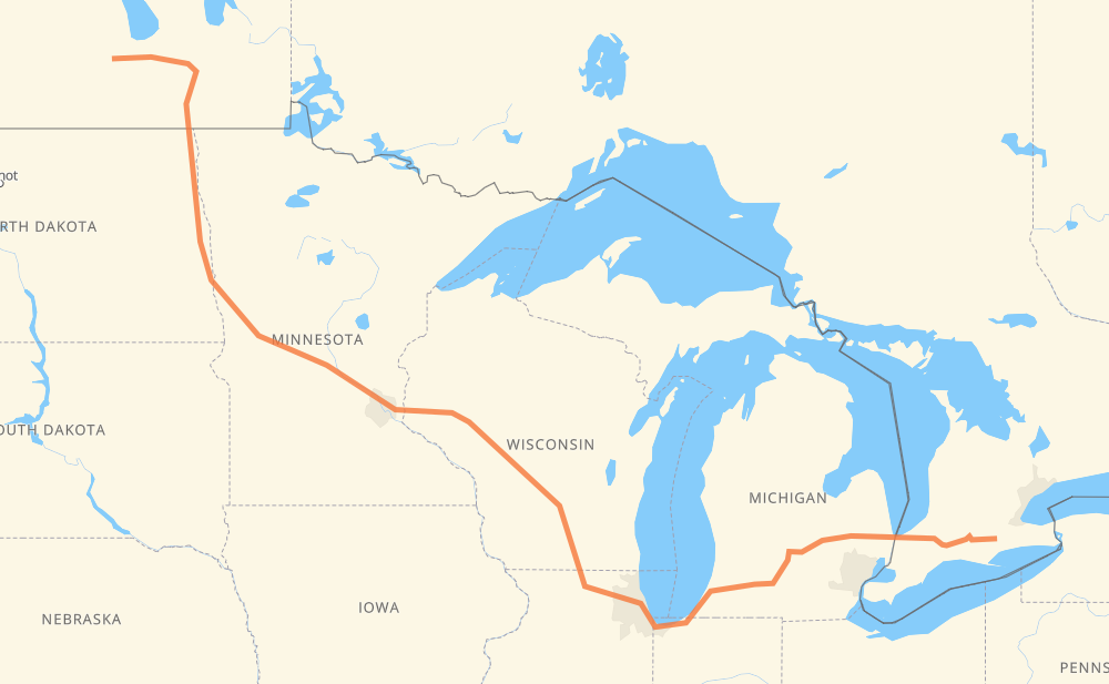
The distance from Austin to Boston is 1,404 miles by road including 1,228 miles on motorways. Road takes approximately 22 hours and 28 minutes and goes through Portage la Prairie, Winnipeg, Grand Forks, Fargo, Eau Claire, Madison and Janesville.
| Shortest distance by air | 1,007 mi ✈️ |
| Car route length | 1,403.7 mi 🚗 |
| Driving time | 22 h 28 min |
| Fuel amount | 47.7 gal |
| Fuel cost | 186.2 USD |
| Point | Distance | Time | Fuel | |
| Austin | 0 mi | 00 min | 0.0 gal | |
|
PTH 1 30 mi, 34 min
|
||||
| Portage la Prairie | 30 mi | 34 min | 0.9 gal | |
|
PTH 1 53 mi, 58 min
|
||||
| Winnipeg | 83 mi | 1 h 32 min | 2.5 gal | |
|
PTH 100 I 29 142 mi, 2 h 34 min
|
||||
| Grand Forks | 225 mi | 4 h 07 min | 7.5 gal | |
|
I 29 74 mi, 1 h 17 min
|
||||
| Fargo | 299 mi | 5 h 24 min | 10.0 gal | |
|
I 29 I 94 327 mi, 5 h 03 min
|
||||
| Eau Claire | 626 mi | 10 h 28 min | 21.0 gal | |
|
I 94 175 mi, 2 h 35 min
|
||||
| Madison | 802 mi | 13 h 03 min | 27.1 gal | |
|
I 39 35 mi, 30 min
|
||||
| Janesville | 836 mi | 13 h 34 min | 28.3 gal | |
|
I 39 I 90 107 mi, 1 h 39 min
|
||||
| Chicago | 944 mi | 15 h 14 min | 31.6 gal | |
|
I 90 I 94 144 mi, 2 h 12 min
|
||||
| Kalamazoo | 1,087 mi | 17 h 26 min | 37.0 gal | |
|
I 94 I 69 65 mi, 56 min
|
||||
| Lansing | 1,152 mi | 18 h 23 min | 39.2 gal | |
|
I 69 62 mi, 54 min
|
||||
| Flint | 1,214 mi | 19 h 18 min | 41.2 gal | |
|
I 69 76 mi, 1 h 14 min
|
||||
| Sarnia | 1,290 mi | 20 h 33 min | 43.7 gal | |
|
402 114 mi, 1 h 55 min
|
||||
| Boston | 1,404 mi | 22 h 28 min | 47.7 gal | |
Frequently Asked Questions
How much does it cost to drive from Austin to Boston?
Fuel cost: 186.2 USD
This fuel cost is calculated as: (Route length 1,403.7 mi) / (Fuel consumption 29.4 mpg) * (Fuel price 3.9 USD / gal)
You can adjust fuel consumption and fuel price here.
How long is a car ride from Austin to Boston?
Driving time: 22 h 28 min
This time is calculated for driving at the maximum permitted speed, taking into account traffic rules restrictions.
- 831 mi with a maximum speed 68 mph = 12 h 12 min
- 17 mi with a maximum speed 65 mph = 15 min
- 229 mi with a maximum speed 62 mph = 3 h 40 min
- 21 mi with a maximum speed 60 mph = 20 min
- 119 mi with a maximum speed 56 mph = 2 h 7 min
- 25 mi with a maximum speed 55 mph = 27 min
- 142 mi with a maximum speed 50 mph = 2 h 51 min
- 8 mi with a maximum speed 45 mph = 10 min
- 5 mi with a maximum speed 43 mph = 6 min
- 1 mi with a maximum speed 37 mph = 2 min
- 1 mi with a maximum speed 35 mph = 1 min
- 4 mi with a maximum speed 31 mph = 7 min
- 1 mi with a maximum speed 25 mph = 2 min
The calculated driving time does not take into account intermediate stops and traffic jams.
How far is Austin to Boston by land?
The distance between Austin and Boston is 1,403.7 mi by road including 1,227.8 mi on motorways.
Precise satellite coordinates of highways were used for this calculation. The start and finish points are the centers of Austin and Boston respectively.
How far is Austin to Boston by plane?
The shortest distance (air line, as the crow flies) between Austin and Boston is 1,006.6 mi.
This distance is calculated using the Haversine formula as a great-circle distance between two points on the surface of a sphere. The start and finish points are the centers of Austin and Boston respectively. Actual distance between airports may be different.
How many hours is Austin from Boston by plane?
Boeing 737 airliner needs 2 h 1 min to cover the distance of 1,007 mi at a cruising speed of 497 mph.
Small plane "Cessna 172" needs 7 h 21 min to flight this distance at average speed of 136 mph.
This time is approximate and do not take into account takeoff and landing times, airport location and other real world factors.
How long is a helicopter ride from Austin to Boston?
Fast helicopter "Eurocopter AS350" or "Hughes OH-6 Cayuse" need 6 h 45 min to cover the distance of 1,007 mi at a cruising speed of 149 mph.
Popular "Robinson R44" needs 7 h 42 min to flight this distance at average speed of 130 mph.
This time is approximate and do not take into account takeoff and landing times, aerodrome location and other real world factors.
What city is halfway between Austin and Boston?
The halfway point between Austin and Boston is Oakdale. It is located about 11 mi from the exact midpoint by road.
The distance from Oakdale to Austin is 713 mi and driving will take about 11 h 44 min. The road between Oakdale and Boston has length 692 mi and will take approximately 10 h 44 min.
The other cities located close to halfway point:
Where is Austin in relation to Boston?
Austin is located 1,007 mi north-west of Boston.
Austin has geographic coordinates: latitude 49.94871, longitude -98.9365.
Boston has geographic coordinates: latitude 42.99083, longitude -80.27051.
Which highway goes from Austin to Boston?
The route from Austin to Boston follows I 94, I 90, I 69, I 29, US 81, I 39, PTH 1, 402.
Other minor sections pass along the road:
- PTH 75: 58 mi
- I 694: 29 mi
- 401: 21 mi
- US 51: 20 mi
- PTH 100: 14 mi
- US 59: 11 mi
- 19: 9 mi
- 3: 9 mi
- 18: 7 mi
- I 96: 4 mi
- US 10: 4 mi
- MN 95: 4 mi
- US 12: 4 mi
- MN 210: 3 mi
- 24: 3 mi
- US 52: 3 mi
- US 31: 3 mi
- WI 35: 2 mi
- WI 11: 2 mi
- Route 42: 1 mi
- 13: 1 mi