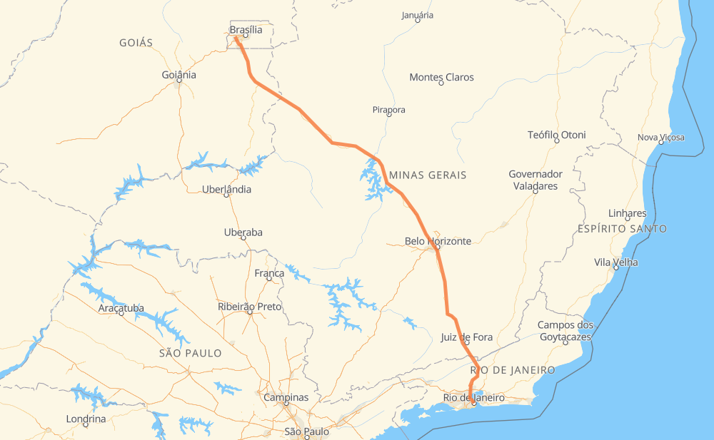
Distance between Ceilândia and Rio de Janeiro
The distance from Ceilândia to Rio de Janeiro is 722 miles by road including 227 miles on motorways. Road takes approximately 13 hours and 15 minutes and goes through Recanto das Emas, Valparaíso de Goiás, Ribeirão das Neves, Conselheiro Lafaiete and Barbacena.
| Shortest distance by air | 585 mi ✈️ |
| Car route length | 722 mi 🚗 |
| Driving time | 13 h 15 min |
| Fuel amount | 24.6 gal |
| Fuel cost | 95.8 USD |
| Point | Distance | Time | Fuel | |
| Ceilândia | 0 mi | 00 min | 0.0 gal | |
|
DF-085 6 mi, 09 min
|
||||
| Setor de Mansões de Samambaia - SMSE - Setor de Mansões Sudeste | 6 mi | 09 min | 0.2 gal | |
|
4 mi, 05 min
|
||||
| Recanto das Emas | 11 mi | 15 min | 0.2 gal | |
|
DF-001 6 mi, 06 min
|
||||
| Área Alfa | 16 mi | 22 min | 0.5 gal | |
|
DF-001 BR-040 12 mi, 18 min
|
||||
| Valparaíso de Goiás | 28 mi | 40 min | 0.6 gal | |
|
BR-040 14 mi, 20 min
|
||||
| Parque Jardim São Paulo | 42 mi | 1 h 01 min | 1.3 gal | |
|
BR-040 396 mi, 7 h 02 min
|
||||
| Ribeirão das Neves | 438 mi | 8 h 03 min | 14.8 gal | |
|
BR-040 75 mi, 1 h 27 min
|
||||
| Conselheiro Lafaiete | 512 mi | 9 h 31 min | 17.2 gal | |
|
BR-040 47 mi, 54 min
|
||||
| Barbacena | 559 mi | 10 h 26 min | 18.9 gal | |
|
BR-040 165 mi, 2 h 48 min
|
||||
| Rio de Janeiro | 724 mi | 13 h 14 min | 24.6 gal | |
Hotels of Rio de Janeiro
Frequently Asked Questions
How much does it cost to drive from Ceilândia to Rio de Janeiro?
Fuel cost: 95.8 USD
This fuel cost is calculated as: (Route length 722 mi) / (Fuel consumption 29.4 mpg) * (Fuel price 3.9 USD / gal)
You can adjust fuel consumption and fuel price here.
How long is a car ride from Ceilândia to Rio de Janeiro?
Driving time: 13 h 15 min
This time is calculated for driving at the maximum permitted speed, taking into account traffic rules restrictions.
- 125 mi with a maximum speed 68 mph = 1 h 50 min
- 43 mi with a maximum speed 62 mph = 41 min
- 377 mi with a maximum speed 56 mph = 6 h 43 min
- 14 mi with a maximum speed 56 mph = 14 min
- 103 mi with a maximum speed 50 mph = 2 h 3 min
- 22 mi with a maximum speed 43 mph = 29 min
- 36 mi with a maximum speed 37 mph = 57 min
- 1 mi with a maximum speed 31 mph = 2 min
- 4 mi with a maximum speed 25 mph = 10 min
The calculated driving time does not take into account intermediate stops and traffic jams.
How far is Ceilândia to Rio de Janeiro by land?
The distance between Ceilândia and Rio de Janeiro is 722 mi by road including 227.4 mi on motorways.
Precise satellite coordinates of highways were used for this calculation. The start and finish points are the centers of Ceilândia and Rio de Janeiro respectively.
How far is Ceilândia to Rio de Janeiro by plane?
The shortest distance (air line, as the crow flies) between Ceilândia and Rio de Janeiro is 584.7 mi.
This distance is calculated using the Haversine formula as a great-circle distance between two points on the surface of a sphere. The start and finish points are the centers of Ceilândia and Rio de Janeiro respectively. Actual distance between airports may be different.
How many hours is Ceilândia from Rio de Janeiro by plane?
Boeing 737 airliner needs 1 h 10 min to cover the distance of 585 mi at a cruising speed of 497 mph.
Small plane "Cessna 172" needs 4 h 16 min to flight this distance at average speed of 136 mph.
This time is approximate and do not take into account takeoff and landing times, airport location and other real world factors.
How long is a helicopter ride from Ceilândia to Rio de Janeiro?
Fast helicopter "Eurocopter AS350" or "Hughes OH-6 Cayuse" need 3 h 55 min to cover the distance of 585 mi at a cruising speed of 149 mph.
Popular "Robinson R44" needs 4 h 28 min to flight this distance at average speed of 130 mph.
This time is approximate and do not take into account takeoff and landing times, aerodrome location and other real world factors.
What city is halfway between Ceilândia and Rio de Janeiro?
The halfway point between Ceilândia and Rio de Janeiro is Paraopeba. It is located about 34 mi from the exact midpoint by road.
The distance from Paraopeba to Ceilândia is 395 mi and driving will take about 7 h 22 min. The road between Paraopeba and Rio de Janeiro has length 327 mi and will take approximately 5 h 52 min.
The other cities located close to halfway point:
Where is Ceilândia in relation to Rio de Janeiro?
Ceilândia is located 585 mi north-west of Rio de Janeiro.
Ceilândia has geographic coordinates: latitude -15.81734, longitude -48.10458.
Rio de Janeiro has geographic coordinates: latitude -22.91101, longitude -43.20937.
Which highway goes from Ceilândia to Rio de Janeiro?
The route from Ceilândia to Rio de Janeiro follows BR-040, BR-135.
Other minor sections pass along the road:
- BR-050: 53 mi
- BR-356: 12 mi
- DF-001: 9 mi
- BR-101: 7 mi
- BR-116: 5 mi
- MG-353: 2 mi
- DF-003: 1 mi
- DF-085: 1 mi
- BR 040: 1 mi
- BR-381: 1 mi
- BR-262: 1 mi