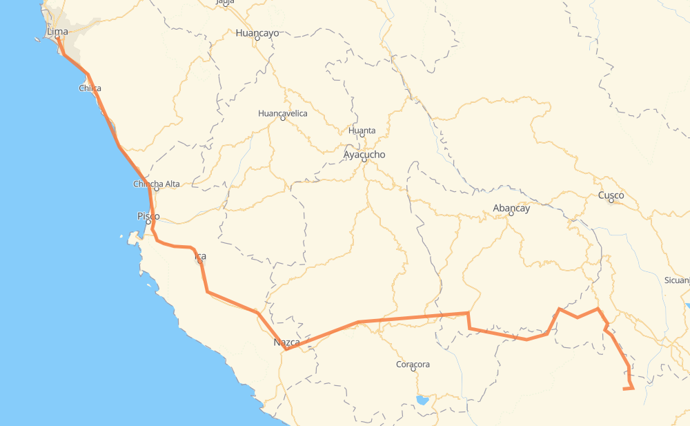
The distance from Central to Lima is 693 miles by road including 134 miles on motorways. Road takes approximately 13 hours and 50 minutes and goes through Caylloma, Cayarani, Santo Tomás, Lucanas, Santiago, Subtanjalla and Guadalupe.
You can adjust fuel consumption and fuel price here.
How long is a car ride from Central to Lima?
Driving time:
13 h 50 min
This time is calculated for driving at the maximum permitted speed, taking into account traffic rules restrictions.
101 mi with a maximum speed 62 mph = 1 h 37 min
183 mi with a maximum speed 56 mph = 3 h 16 min
14 mi with a maximum speed 56 mph = 14 min
308 mi with a maximum speed 50 mph = 6 h 11 min
68 mi with a maximum speed 37 mph = 1 h 48 min
16 mi with a maximum speed 31 mph = 29 min
3 mi with a maximum speed 25 mph = 7 min
1 mi with a maximum speed 22 mph = 4 min
The calculated driving time does not take into account intermediate stops and traffic jams.
How far is Central to Lima by land?
The distance between Central and Lima is 692.8 mi by road including 133.6 mi on motorways.
Precise satellite coordinates of highways were used for this calculation. The start and finish points are the centers of Central and Lima respectively.
How far is Central to Lima by plane?
The shortest distance (air line, as the crow flies) between Central and Lima is 409.5 mi.
This distance is calculated using the Haversine formula as a great-circle distance between two points on the surface of a sphere. The start and finish points are the centers of Central and Lima respectively. Actual distance between airports may be different.
How many hours is Central from Lima by plane?
Boeing 737 airliner needs 49 min to cover the distance of 409 mi at a cruising speed of 497 mph.
Small plane "Cessna 172" needs 2 h 59 min to flight this distance at average speed of 136 mph.
This time is approximate and do not take into account takeoff and landing times, airport location and other real world factors.
How long is a helicopter ride from Central to Lima?
Fast helicopter "Eurocopter AS350" or "Hughes OH-6 Cayuse" need 2 h 44 min to cover the distance of 409 mi at a cruising speed of 149 mph.
Popular "Robinson R44" needs 3 h 8 min to flight this distance at average speed of 130 mph.
This time is approximate and do not take into account takeoff and landing times, aerodrome location and other real world factors.
What city is halfway between Central and Lima?
The halfway point between Central and Lima is Santiago de Vado.
The distance from Santiago de Vado to Central is 346 mi and driving will take about 6 h 47 min. The road between Santiago de Vado and Lima has length 347 mi and will take approximately 7 h 2 min.
The other cities located close to halfway point:
Lucanas is in 340 mi from Central and 353 mi from Lima
Ccollpa Pampa is in 357 mi from Central and 336 mi from Lima
Pampa Sano is in 331 mi from Central and 362 mi from Lima
Where is Central in relation to Lima?
Central is located 409 mi south-east of Lima.
Central has geographic coordinates: latitude -15.19318, longitude -71.85945.
Lima has geographic coordinates: latitude -12.06211, longitude -77.03653.
Which highway goes from Central to Lima?
The route from Central to Lima follows PE-1S, PE-30A, AP-111.