Distance between Chihuahua and Orizaba
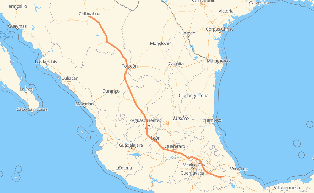
The distance from Chihuahua to Orizaba is 1,054 miles by road including 720 miles on motorways. Road takes approximately 17 hours and 46 minutes and goes through Delicias, Camargo, Jiménez, Fresnillo, Aguascalientes, Salamanca and Celaya.
| Shortest distance by air | 884 mi ✈️ |
| Car route length | 1,053.8 mi 🚗 |
| Driving time | 17 h 46 min |
| Fuel amount | 35.8 gal |
| Fuel cost | 140.9 USD |
| Toll roads cost | 1,433 + ? MXN |
| Point | Distance | Time | Fuel | |
| Chihuahua | 0 mi | 00 min | 0.0 gal | |
|
MEX 45 38 mi, 42 min
|
||||
| Lazaro Cardenas | 38 mi | 42 min | 1.1 gal | |
|
MEX 45 14 mi, 15 min
|
||||
| Delicias | 53 mi | 57 min | 1.7 gal | |
|
MEX 45 MEX 45D 43 mi, 40 min
|
||||
| Camargo | 96 mi | 1 h 38 min | 3.1 gal | |
|
CHIH 187 MEX 45D 28 mi, 28 min
|
||||
| Jiménez | 124 mi | 2 h 06 min | 3.5 gal | |
|
MEX 45D MEX 49D 358 mi, 6 h 01 min
|
||||
| Fresnillo | 482 mi | 8 h 08 min | 16.2 gal | |
|
MEX 45D 111 mi, 1 h 58 min
|
||||
| Aguascalientes | 592 mi | 10 h 07 min | 20.0 gal | |
|
MEX 70 MEX 45D 127 mi, 1 h 58 min
|
||||
| Salamanca | 720 mi | 12 h 06 min | 24.5 gal | |
|
MEX 45D 19 mi, 18 min
|
||||
| Celaya | 739 mi | 12 h 24 min | 25.0 gal | |
|
MEX 45D MEX M40D 318 mi, 5 h 21 min
|
||||
| Orizaba | 1,056 mi | 17 h 46 min | 35.8 gal | |
Frequently Asked Questions
How many toll booths are there from Chihuahua to Orizaba?
There are 25 toll booths between Chihuahua and Orizaba: Saucillo, Camargo, Jimenez, Savalza, León Guzmán, Ceballos, Bermejillo, Cuencame, Morfín Chávez, Calera, Veta Grande, Zacatecas, Encarnacion De Diaz, León - Aguascalientes, Puerto Interior, Mendoza, Cerro Gordo, Queretaro, Palmillas, Palmilas - Apaseo, San Martin Texmelucan, San Martín, Viaducto Elevado de Puebla, Amozoc and Esperanza 27.
How much does the toll booths cost from Chihuahua to Orizaba?
Toll roads cost: Saucillo (71 MXN) + Camargo (71 MXN) + Jimenez (97 MXN) + Savalza (71 MXN) + Ceballos (145 MXN) + Bermejillo (127 MXN) + León Guzmán (?) + Cuencame (?) + Morfín Chávez (40 MXN) + Calera (23 MXN) + Veta Grande (48 MXN) + Zacatecas (41 MXN) + Encarnacion De Diaz (150 MXN) + León - Aguascalientes (153 MXN) + Puerto Interior (?) + Mendoza (53 MXN) + Cerro Gordo (?) + Palmilas - Apaseo (?) + Palmillas (89 MXN) + Queretaro (?) + San Martin Texmelucan (?) + San Martín (42 MXN) + Viaducto Elevado de Puebla (?) + Amozoc (72 MXN) + Esperanza 27 (140 MXN) = 1,433 + ? MXN
How much does it cost to drive from Chihuahua to Orizaba?
Fuel cost: 140.9 USD
This fuel cost is calculated as: (Route length 1,053.8 mi) / (Fuel consumption 29.4 mpg) * (Fuel price 3.93 USD / gal)
You can adjust fuel consumption and fuel price here.
Toll roads cost: 1,433 + ? MXN
How long is a car ride from Chihuahua to Orizaba?
Driving time: 17 h 46 min
This time is calculated for driving at the maximum permitted speed, taking into account traffic rules restrictions.
- 288 mi with a maximum speed 68 mph = 4 h 14 min
- 331 mi with a maximum speed 62 mph = 5 h 18 min
- 206 mi with a maximum speed 56 mph = 3 h 40 min
- 96 mi with a maximum speed 56 mph = 1 h 42 min
- 124 mi with a maximum speed 50 mph = 2 h 29 min
- 4 mi with a maximum speed 43 mph = 4 min
- 6 mi with a maximum speed 37 mph = 9 min
- 2 mi with a maximum speed 31 mph = 4 min
- 1 mi with a maximum speed 19 mph = 2 min
The calculated driving time does not take into account intermediate stops and traffic jams.
How far is Chihuahua to Orizaba by land?
The distance between Chihuahua and Orizaba is 1,053.8 mi by road including 720.2 mi on motorways.
Precise satellite coordinates of highways were used for this calculation. The start and finish points are the centers of Chihuahua and Orizaba respectively.
How far is Chihuahua to Orizaba by plane?
The shortest distance (air line, as the crow flies) between Chihuahua and Orizaba is 883.6 mi.
This distance is calculated using the Haversine formula as a great-circle distance between two points on the surface of a sphere. The start and finish points are the centers of Chihuahua and Orizaba respectively. Actual distance between airports may be different.
How many hours is Chihuahua from Orizaba by plane?
Boeing 737 airliner needs 1 h 46 min to cover the distance of 884 mi at a cruising speed of 497 mph.
Small plane "Cessna 172" needs 6 h 27 min to flight this distance at average speed of 136 mph.
This time is approximate and do not take into account takeoff and landing times, airport location and other real world factors.
How long is a helicopter ride from Chihuahua to Orizaba?
Fast helicopter "Eurocopter AS350" or "Hughes OH-6 Cayuse" need 5 h 55 min to cover the distance of 884 mi at a cruising speed of 149 mph.
Popular "Robinson R44" needs 6 h 46 min to flight this distance at average speed of 130 mph.
This time is approximate and do not take into account takeoff and landing times, aerodrome location and other real world factors.
What city is halfway between Chihuahua and Orizaba?
The halfway point between Chihuahua and Orizaba is Sauceda de la Borda. It is located about 9 mi from the exact midpoint by road.
The distance from Sauceda de la Borda to Chihuahua is 518 mi and driving will take about 8 h 45 min. The road between Sauceda de la Borda and Orizaba has length 536 mi and will take approximately 9 h 1 min.
The other cities located close to halfway point:
Where is Chihuahua in relation to Orizaba?
Chihuahua is located 884 mi north-west of Orizaba.
Chihuahua has geographic coordinates: latitude 28.66057, longitude -106.07498.
Orizaba has geographic coordinates: latitude 18.84972, longitude -97.10361.
Which highway goes from Chihuahua to Orizaba?
The route from Chihuahua to Orizaba follows MEX 45D, MEX 49D, MEX 49, MEX 45, MEX M40D, MEX 150D.
Other minor sections pass along the road:
- MEX 40D: 53 mi
- MEX 47D: 52 mi
- MEX 43D: 48 mi
- MEX 57D: 35 mi
- MEX 70: 33 mi
- MEX 40: 6 mi
- CHIH 187: 4 mi
- MEX 150: 2 mi
- MEX 40D:MEX 49D: 2 mi
- MEX 54: 1 mi
- CHIH 69: 1 mi