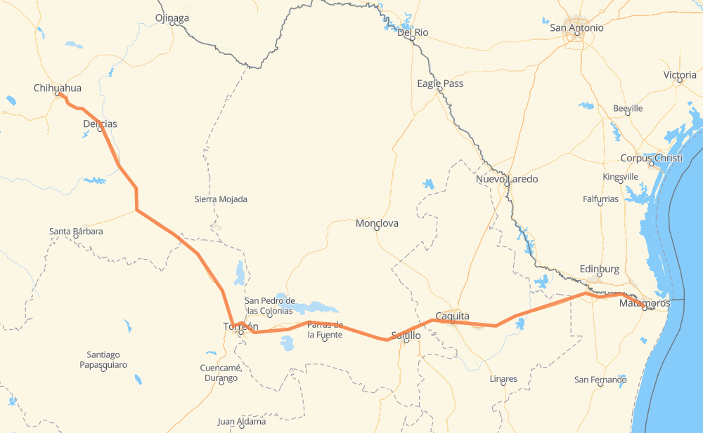
Distance between Chihuahua and Matamoros
The distance from Chihuahua to Matamoros is 692 miles by road including 441 miles on motorways. Road takes approximately 11 hours and 43 minutes and goes through Delicias, Camargo, Jiménez, Monterrey, Guadalupe, Reynosa and Río Bravo.
| Shortest distance by air | 560 mi ✈️ |
| Car route length | 692.2 mi 🚗 |
| Driving time | 11 h 43 min |
| Fuel amount | 23.5 gal |
| Fuel cost | 92.5 USD |
| Toll roads cost | 1,388 + ? MXN |
| Point | Distance | Time | Fuel | |
| Chihuahua | 0 mi | 00 min | 0.0 gal | |
|
MEX 45 38 mi, 42 min
|
||||
| Lazaro Cardenas | 38 mi | 42 min | 1.1 gal | |
|
MEX 45 14 mi, 15 min
|
||||
| Delicias | 53 mi | 57 min | 1.7 gal | |
|
MEX 45 MEX 45D 43 mi, 40 min
|
||||
| Camargo | 96 mi | 1 h 38 min | 3.1 gal | |
|
CHIH 187 MEX 45D 28 mi, 28 min
|
||||
| Jiménez | 124 mi | 2 h 06 min | 3.5 gal | |
|
MEX 45D MEX 40D 378 mi, 6 h 21 min
|
||||
| Monterrey | 502 mi | 8 h 28 min | 16.9 gal | |
|
20 4 mi, 05 min
|
||||
| Guadalupe | 506 mi | 8 h 33 min | 17.2 gal | |
|
MEX 40 MEX 40D 132 mi, 2 h 07 min
|
||||
| Reynosa | 638 mi | 10 h 41 min | 21.7 gal | |
|
MEX 2 17 mi, 18 min
|
||||
| Río Bravo | 656 mi | 11 h 00 min | 22.2 gal | |
|
MEX 2D 40 mi, 43 min
|
||||
| Matamoros | 696 mi | 11 h 43 min | 23.6 gal | |
Hotels of Matamoros
Frequently Asked Questions
How many toll booths are there from Chihuahua to Matamoros?
There are 16 toll booths between Chihuahua and Matamoros: Saucillo, Camargo, Jimenez, Savalza, Ojo Caliente, Torreon, Plan de Ayala, La Cuchilla, San Pedro km 16+830, Periférico, Guadalupe Reynosa, Cadereyta REA, General Bravo, Nuevo Progreso, Ceballos and Bermejillo.
How much does the toll booths cost from Chihuahua to Matamoros?
Toll roads cost: Saucillo (71 MXN) + Camargo (71 MXN) + Jimenez (97 MXN) + Savalza (71 MXN) + Ceballos (145 MXN) + Bermejillo (127 MXN) + San Pedro km 16+830 (?) + La Cuchilla (79 MXN) + Plan de Ayala (139 MXN) + Torreon (17 MXN) + Ojo Caliente (20 MXN) + Periférico (103 MXN) + Guadalupe Reynosa (?) + Cadereyta REA (81 MXN) + General Bravo (284 MXN) + Nuevo Progreso (83 MXN) = 1,388 + ? MXN
How much does it cost to drive from Chihuahua to Matamoros?
Fuel cost: 92.5 USD
This fuel cost is calculated as: (Route length 692.2 mi) / (Fuel consumption 29.4 mpg) * (Fuel price 3.93 USD / gal)
You can adjust fuel consumption and fuel price here.
Toll roads cost: 1,388 + ? MXN
How long is a car ride from Chihuahua to Matamoros?
Driving time: 11 h 43 min
This time is calculated for driving at the maximum permitted speed, taking into account traffic rules restrictions.
- 226 mi with a maximum speed 68 mph = 3 h 19 min
- 189 mi with a maximum speed 62 mph = 3 h 2 min
- 37 mi with a maximum speed 56 mph = 39 min
- 163 mi with a maximum speed 56 mph = 2 h 55 min
- 59 mi with a maximum speed 50 mph = 1 h 11 min
- 4 mi with a maximum speed 43 mph = 5 min
- 17 mi with a maximum speed 37 mph = 27 min
- 1 mi with a maximum speed 25 mph = 1 min
- 1 mi with a maximum speed 19 mph = 1 min
The calculated driving time does not take into account intermediate stops and traffic jams.
How far is Chihuahua to Matamoros by land?
The distance between Chihuahua and Matamoros is 692.2 mi by road including 441.2 mi on motorways.
Precise satellite coordinates of highways were used for this calculation. The start and finish points are the centers of Chihuahua and Matamoros respectively.
How far is Chihuahua to Matamoros by plane?
The shortest distance (air line, as the crow flies) between Chihuahua and Matamoros is 560.5 mi.
This distance is calculated using the Haversine formula as a great-circle distance between two points on the surface of a sphere. The start and finish points are the centers of Chihuahua and Matamoros respectively. Actual distance between airports may be different.
How many hours is Chihuahua from Matamoros by plane?
Boeing 737 airliner needs 1 h 7 min to cover the distance of 560 mi at a cruising speed of 497 mph.
Small plane "Cessna 172" needs 4 h 5 min to flight this distance at average speed of 136 mph.
This time is approximate and do not take into account takeoff and landing times, airport location and other real world factors.
How long is a helicopter ride from Chihuahua to Matamoros?
Fast helicopter "Eurocopter AS350" or "Hughes OH-6 Cayuse" need 3 h 45 min to cover the distance of 560 mi at a cruising speed of 149 mph.
Popular "Robinson R44" needs 4 h 17 min to flight this distance at average speed of 130 mph.
This time is approximate and do not take into account takeoff and landing times, aerodrome location and other real world factors.
What city is halfway between Chihuahua and Matamoros?
The halfway point between Chihuahua and Matamoros is Ejido El Sol. It is located about 1 mi from the exact midpoint by road.
The distance from Ejido El Sol to Chihuahua is 347 mi and driving will take about 5 h 53 min. The road between Ejido El Sol and Matamoros has length 345 mi and will take approximately 5 h 49 min.
The other cities located close to halfway point:
Where is Chihuahua in relation to Matamoros?
Chihuahua is located 560 mi north-west of Matamoros.
Chihuahua has geographic coordinates: latitude 28.66057, longitude -106.07498.
Matamoros has geographic coordinates: latitude 25.87047, longitude -97.50668.
Which highway goes from Chihuahua to Matamoros?
The route from Chihuahua to Matamoros follows MEX 40D, MEX 49D, MEX 40, MEX 45D.
Other minor sections pass along the road:
- MEX 45: 53 mi
- MEX 2D: 28 mi
- MEX 2: 27 mi
- MEX 49: 23 mi
- 20: 11 mi
- 22: 9 mi
- MEX-40: 4 mi
- CHIH 187: 4 mi
- 410: 1 mi
- CHIH 69: 1 mi